You are here: Home > Network List > MN - MEDNET Project Stations List
> Station TIP Timpagrande, Italy > Earthquake Result Viewer
TIP Timpagrande, Italy - Earthquake Result Viewer
| Earthquake location: |
Hokkaido, Japan Region |
| Earthquake latitude/longitude: |
43.0/145.1 |
| Earthquake time(UTC): |
2004/11/28 (333) 18:32:14 GMT |
| Earthquake Depth: |
39 km |
| Earthquake Magnitude: |
6.4 MB, 6.7 MS, 7.0 MW, 7.0 MW |
| Earthquake Catalog/Contributor: |
WHDF/NEIC |
|
| Network: |
MN MEDNET Project |
| Station: |
TIP Timpagrande, Italy |
| Lat/Lon: |
39.18 N/16.76 E |
| Elevation: |
789 m |
|
| Distance: |
85.8 deg |
| Az: |
322.33 deg |
| Baz: |
35.224 deg |
| Ray Param: |
0.044470243 |
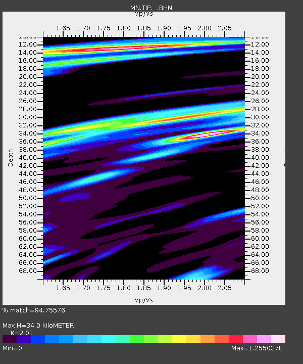
| Estimated Moho Depth: |
34.0 km |
| Estimated Crust Vp/Vs: |
2.01 |
| Assumed Crust Vp: |
6.1 km/s |
| Estimated Crust Vs: |
3.035 km/s |
| Estimated Crust Poisson's Ratio: |
0.34 |
|
| Radial Match: |
94.75576 % |
| Radial Bump: |
400 |
| Transverse Match: |
93.25513 % |
| Transverse Bump: |
400 |
| SOD ConfigId: |
2459 |
| Insert Time: |
2010-03-08 17:21:12.032 +0000 |
| GWidth: |
2.5 |
| Max Bumps: |
400 |
| Tol: |
0.001 |
|
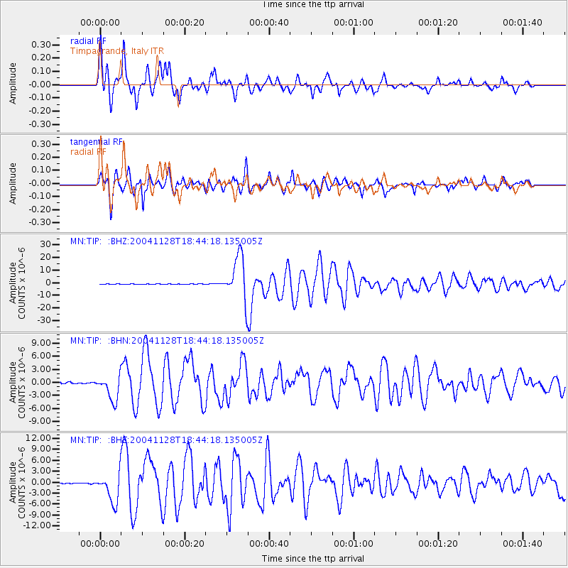
Signal To Noise
| Channel | StoN | STA | LTA |
| MN:TIP: :BHN:20041128T18:44:18.135005Z | 21.571995 | 3.0264428E-6 | 1.4029499E-7 |
| MN:TIP: :BHE:20041128T18:44:18.135005Z | 45.908104 | 4.194671E-6 | 9.137104E-8 |
| MN:TIP: :BHZ:20041128T18:44:18.135005Z | 176.82733 | 1.7962184E-5 | 1.01580355E-7 |
| Arrivals |
| Ps | 5.7 SECOND |
| PpPs | 16 SECOND |
| PsPs/PpSs | 22 SECOND |


