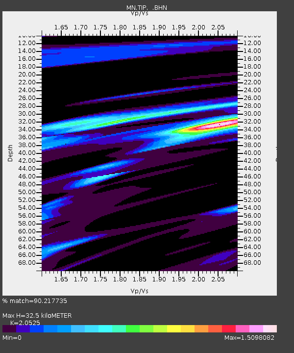
TIP Timpagrande, Italy - Earthquake Result Viewer
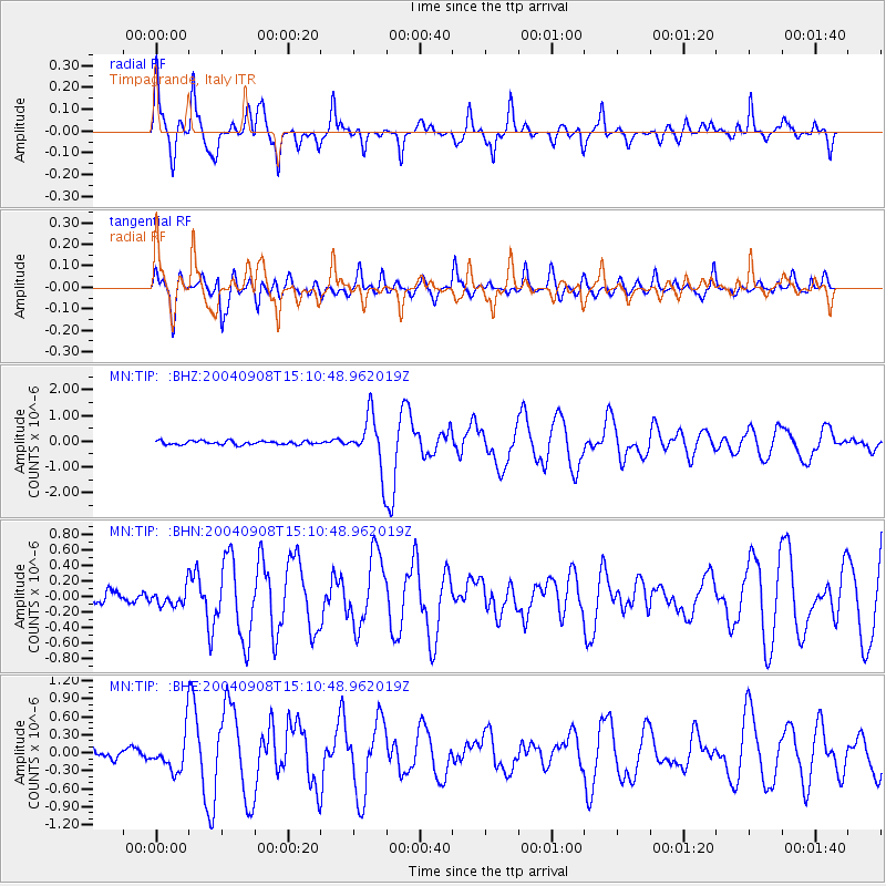
Earthquake location: Near S. Coast Of Honshu, Japan
Earthquake latitude/longitude: 33.1/137.2
Earthquake time(UTC): 2004/09/08 (252) 14:58:25 GMT
Earthquake Depth: 21 km
Earthquake Magnitude: 6.2 MB, 5.8 MS, 6.2 MW, 6.1 MW
Earthquake Catalog/Contributor: WHDF/NEIC
Network: MN MEDNET Project
Station: TIP Timpagrande, Italy
Lat/Lon: 39.18 N/16.76 E
Elevation: 789 m
Distance: 89.3 deg
Az: 317.922 deg
Baz: 46.336 deg
Ray Param: 0.0419209
Estimated Moho Depth: 32.5 km
Estimated Crust Vp/Vs: 2.05
Assumed Crust Vp: 6.1 km/s
Estimated Crust Vs: 2.972 km/s
Estimated Crust Poisson's Ratio: 0.34
Radial Match: 90.217735 %
Radial Bump: 400
Transverse Match: 85.70165 %
Transverse Bump: 400
SOD ConfigId: 2459
Insert Time: 2010-03-08 17:21:18.004 +0000
GWidth: 2.5
Max Bumps: 400
Tol: 0.001

Signal To Noise

ChannelStoNSTALTA
MN:TIP: :BHN:20040908T15:10:48.962019Z1.54357781.06628505E-76.907881E-8
MN:TIP: :BHE:20040908T15:10:48.962019Z4.81152633.0214537E-76.279616E-8
MN:TIP: :BHZ:20040908T15:10:48.962019Z14.9142921.0320005E-66.9195394E-8
Arrivals
Ps5.7 SECOND
PpPs16 SECOND
PsPs/PpSs22 SECOND