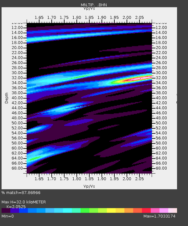
TIP Timpagrande, Italy - Earthquake Result Viewer
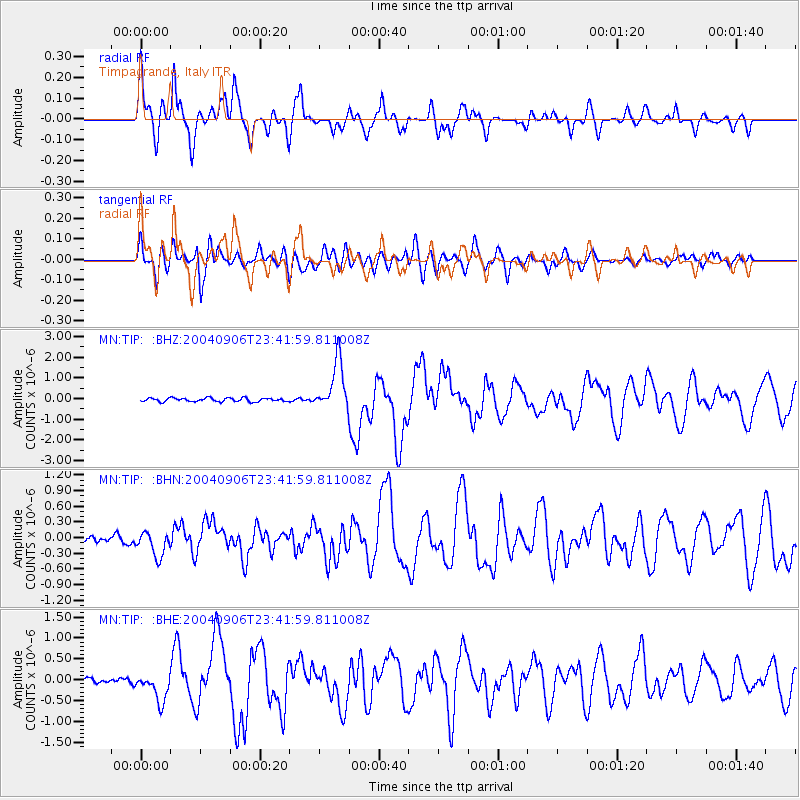
Earthquake location: Near S. Coast Of Honshu, Japan
Earthquake latitude/longitude: 33.2/137.2
Earthquake time(UTC): 2004/09/06 (250) 23:29:35 GMT
Earthquake Depth: 10 km
Earthquake Magnitude: 6.4 MB, 6.3 MS, 6.7 MW, 6.5 MW
Earthquake Catalog/Contributor: WHDF/NEIC
Network: MN MEDNET Project
Station: TIP Timpagrande, Italy
Lat/Lon: 39.18 N/16.76 E
Elevation: 789 m
Distance: 89.3 deg
Az: 317.936 deg
Baz: 46.276 deg
Ray Param: 0.041963674
Estimated Moho Depth: 32.0 km
Estimated Crust Vp/Vs: 2.05
Assumed Crust Vp: 6.1 km/s
Estimated Crust Vs: 2.972 km/s
Estimated Crust Poisson's Ratio: 0.34
Radial Match: 87.86966 %
Radial Bump: 400
Transverse Match: 83.225555 %
Transverse Bump: 400
SOD ConfigId: 2459
Insert Time: 2010-03-08 17:21:19.209 +0000
GWidth: 2.5
Max Bumps: 400
Tol: 0.001

Signal To Noise

ChannelStoNSTALTA
MN:TIP: :BHN:20040906T23:41:59.811008Z4.27385472.3519885E-75.503202E-8
MN:TIP: :BHE:20040906T23:41:59.811008Z5.1237043.4083044E-76.652032E-8
MN:TIP: :BHZ:20040906T23:41:59.811008Z13.8410271.1838143E-68.552937E-8
Arrivals
Ps5.6 SECOND
PpPs16 SECOND
PsPs/PpSs21 SECOND