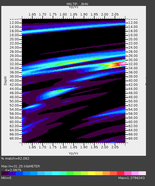
TIP Timpagrande, Italy - Earthquake Result Viewer

Earthquake location: Near S. Coast Of Honshu, Japan
Earthquake latitude/longitude: 33.2/137.1
Earthquake time(UTC): 2004/09/05 (249) 14:57:18 GMT
Earthquake Depth: 10 km
Earthquake Magnitude: 6.2 MB, 7.1 MS, 7.4 MW, 7.4 MW
Earthquake Catalog/Contributor: WHDF/NEIC
Network: MN MEDNET Project
Station: TIP Timpagrande, Italy
Lat/Lon: 39.18 N/16.76 E
Elevation: 789 m
Distance: 89.2 deg
Az: 317.852 deg
Baz: 46.387 deg
Ray Param: 0.04201629
Estimated Moho Depth: 31.25 km
Estimated Crust Vp/Vs: 2.10
Assumed Crust Vp: 6.1 km/s
Estimated Crust Vs: 2.908 km/s
Estimated Crust Poisson's Ratio: 0.35
Radial Match: 92.092 %
Radial Bump: 305
Transverse Match: 92.003624 %
Transverse Bump: 400
SOD ConfigId: 2459
Insert Time: 2010-03-08 17:21:20.362 +0000
GWidth: 2.5
Max Bumps: 400
Tol: 0.001

Signal To Noise

ChannelStoNSTALTA
MN:TIP: :BHN:20040905T15:09:42.961013Z0.58709194.4861224E-87.6412604E-8
MN:TIP: :BHE:20040905T15:09:42.961013Z2.22396091.3258182E-75.9615175E-8
MN:TIP: :BHZ:20040905T15:09:42.961013Z3.2311192.5711404E-77.9574306E-8
Arrivals
Ps5.7 SECOND
PpPs16 SECOND
PsPs/PpSs21 SECOND