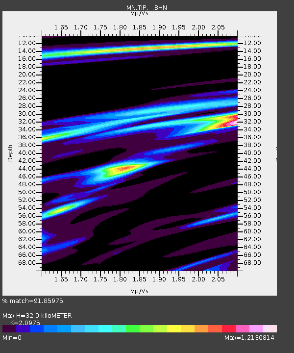
TIP Timpagrande, Italy - Earthquake Result Viewer
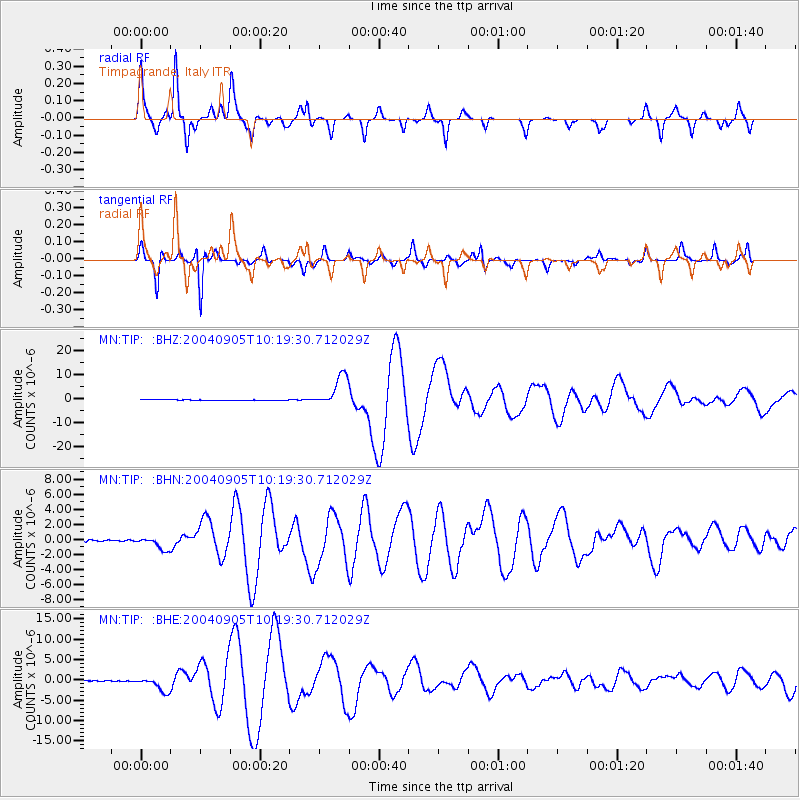
Earthquake location: Near S. Coast Of Western Honshu
Earthquake latitude/longitude: 33.1/136.6
Earthquake time(UTC): 2004/09/05 (249) 10:07:07 GMT
Earthquake Depth: 14 km
Earthquake Magnitude: 6.7 MB, 7.0 MS, 7.2 MW, 7.0 MW
Earthquake Catalog/Contributor: WHDF/NEIC
Network: MN MEDNET Project
Station: TIP Timpagrande, Italy
Lat/Lon: 39.18 N/16.76 E
Elevation: 789 m
Distance: 89.0 deg
Az: 317.611 deg
Baz: 46.745 deg
Ray Param: 0.04213472
Estimated Moho Depth: 32.0 km
Estimated Crust Vp/Vs: 2.10
Assumed Crust Vp: 6.1 km/s
Estimated Crust Vs: 2.908 km/s
Estimated Crust Poisson's Ratio: 0.35
Radial Match: 91.85975 %
Radial Bump: 253
Transverse Match: 95.04671 %
Transverse Bump: 237
SOD ConfigId: 2459
Insert Time: 2010-03-08 17:21:21.506 +0000
GWidth: 2.5
Max Bumps: 400
Tol: 0.001

Signal To Noise

ChannelStoNSTALTA
MN:TIP: :BHN:20040905T10:19:30.712029Z5.99263539.009029E-71.5033501E-7
MN:TIP: :BHE:20040905T10:19:30.712029Z20.666061.8532103E-68.9674096E-8
MN:TIP: :BHZ:20040905T10:19:30.712029Z50.8996966.5034537E-61.2776998E-7
Arrivals
Ps5.9 SECOND
PpPs16 SECOND
PsPs/PpSs22 SECOND