You are here: Home > Network List > MN - MEDNET Project Stations List
> Station TIP Timpagrande, Italy > Earthquake Result Viewer
TIP Timpagrande, Italy - Earthquake Result Viewer

| Earthquake location: |
Hindu Kush Region, Afghanistan |
| Earthquake latitude/longitude: |
36.4/70.8 |
| Earthquake time(UTC): |
2004/08/10 (223) 01:47:32 GMT |
| Earthquake Depth: |
207 km |
| Earthquake Magnitude: |
5.3 MB, 6.0 MW, 6.0 MW |
| Earthquake Catalog/Contributor: |
WHDF/NEIC |
|
| Network: |
MN MEDNET Project |
| Station: |
TIP Timpagrande, Italy |
| Lat/Lon: |
39.18 N/16.76 E |
| Elevation: |
789 m |
|
| Distance: |
42.3 deg |
| Az: |
290.673 deg |
| Baz: |
76.08 deg |
| Ray Param: |
0.0724817 |
| Estimated Moho Depth: |
31.75 km |
| Estimated Crust Vp/Vs: |
1.88 |
| Assumed Crust Vp: |
6.1 km/s |
| Estimated Crust Vs: |
3.236 km/s |
| Estimated Crust Poisson's Ratio: |
0.30 |
|
| Radial Match: |
83.79857 % |
| Radial Bump: |
400 |
| Transverse Match: |
79.01544 % |
| Transverse Bump: |
400 |
| SOD ConfigId: |
2459 |
| Insert Time: |
2010-03-08 17:21:22.768 +0000 |
| GWidth: |
2.5 |
| Max Bumps: |
400 |
| Tol: |
0.001 |
|
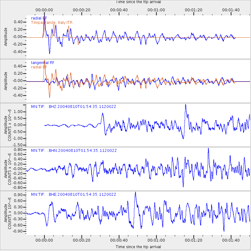
Signal To Noise
| Channel | StoN | STA | LTA |
| MN:TIP: :BHN:20040810T01:54:35.112002Z | 0.92666084 | 4.4220357E-8 | 4.772011E-8 |
| MN:TIP: :BHE:20040810T01:54:35.112002Z | 9.344505 | 3.6603507E-7 | 3.9171155E-8 |
| MN:TIP: :BHZ:20040810T01:54:35.112002Z | 8.995537 | 4.5846735E-7 | 5.096609E-8 |
| Arrivals |
| Ps | 4.9 SECOND |
| PpPs | 14 SECOND |
| PsPs/PpSs | 19 SECOND |


