You are here: Home > Network List > GS - US Geological Survey Networks Stations List
> Station DEC05 Decatur Surface Seismic Site, Decatur, IL, USA > Earthquake Result Viewer
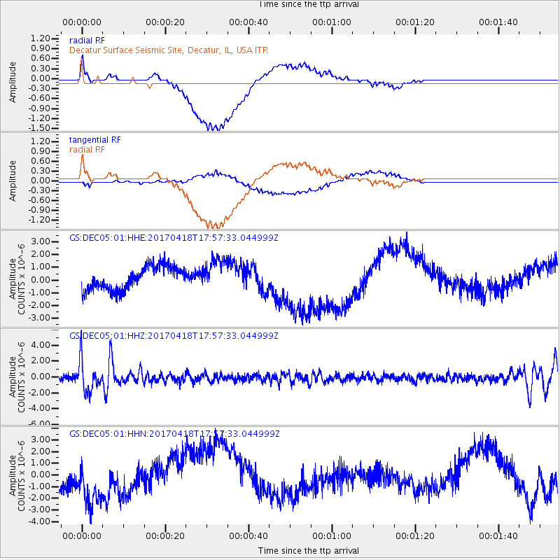
DEC05 Decatur Surface Seismic Site, Decatur, IL, USA - Earthquake Result Viewer
*The percent match for this event was below the threshold and hence no stack was calculated.
| Earthquake location: |
Peru-Ecuador Border Region |
| Earthquake latitude/longitude: |
-2.7/-75.3 |
| Earthquake time(UTC): |
2017/04/18 (108) 17:49:55 GMT |
| Earthquake Depth: |
11 km |
| Earthquake Magnitude: |
6.0 Mww |
| Earthquake Catalog/Contributor: |
NEIC PDE/us |
|
| Network: |
GS US Geological Survey Networks |
| Station: |
DEC05 Decatur Surface Seismic Site, Decatur, IL, USA |
| Lat/Lon: |
39.87 N/88.87 W |
| Elevation: |
216 m |
|
| Distance: |
44.2 deg |
| Az: |
344.993 deg |
| Baz: |
160.362 deg |
| Ray Param: |
$rayparam |
*The percent match for this event was below the threshold and hence was not used in the summary stack. |
|
| Radial Match: |
30.345537 % |
| Radial Bump: |
400 |
| Transverse Match: |
22.326986 % |
| Transverse Bump: |
400 |
| SOD ConfigId: |
2028011 |
| Insert Time: |
2017-05-02 17:53:46.610 +0000 |
| GWidth: |
2.5 |
| Max Bumps: |
400 |
| Tol: |
0.001 |
|
Signal To Noise
| Channel | StoN | STA | LTA |
| GS:DEC05:01:HHZ:20170418T17:57:33.044999Z | 7.6796985 | 2.0022007E-6 | 2.6071348E-7 |
| GS:DEC05:01:HHN:20170418T17:57:33.044999Z | 1.321025 | 2.3440386E-6 | 1.7744089E-6 |
| GS:DEC05:01:HHE:20170418T17:57:33.044999Z | 1.3553472 | 1.2393225E-6 | 9.1439495E-7 |
| Arrivals |
| Ps | |
| PpPs | |
| PsPs/PpSs | |


