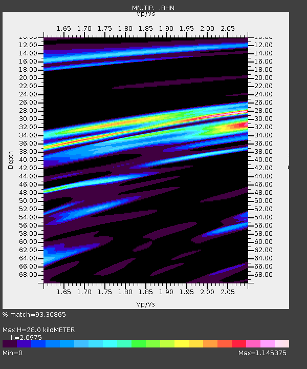
TIP Timpagrande, Italy - Earthquake Result Viewer

Earthquake location: Off East Coast Of Honshu, Japan
Earthquake latitude/longitude: 34.3/141.4
Earthquake time(UTC): 2004/05/29 (150) 20:56:09 GMT
Earthquake Depth: 16 km
Earthquake Magnitude: 5.6 MB, 6.6 MS, 6.5 MW, 6.3 MW
Earthquake Catalog/Contributor: WHDF/NEIC
Network: MN MEDNET Project
Station: TIP Timpagrande, Italy
Lat/Lon: 39.18 N/16.76 E
Elevation: 789 m
Distance: 90.8 deg
Az: 320.248 deg
Baz: 42.961 deg
Ray Param: 0.04164837
Estimated Moho Depth: 28.0 km
Estimated Crust Vp/Vs: 2.10
Assumed Crust Vp: 6.1 km/s
Estimated Crust Vs: 2.908 km/s
Estimated Crust Poisson's Ratio: 0.35
Radial Match: 93.30865 %
Radial Bump: 365
Transverse Match: 89.51121 %
Transverse Bump: 400
SOD ConfigId: 2459
Insert Time: 2010-03-08 17:21:29.979 +0000
GWidth: 2.5
Max Bumps: 400
Tol: 0.001

Signal To Noise

ChannelStoNSTALTA
MN:TIP: :BHN:20040529T21:08:40.261011Z1.42802111.0062266E-77.046301E-8
MN:TIP: :BHE:20040529T21:08:40.261011Z2.32344651.3801474E-75.9400872E-8
MN:TIP: :BHZ:20040529T21:08:40.261011Z8.23819354.813223E-75.842571E-8
Arrivals
Ps5.1 SECOND
PpPs14 SECOND
PsPs/PpSs19 SECOND