You are here: Home > Network List > MM - Myanmar National Seismic Network Stations List
> Station NGU Ngaung U, Myanmar > Earthquake Result Viewer
NGU Ngaung U, Myanmar - Earthquake Result Viewer
| Earthquake location: |
Near North Coast Of Irian Jaya |
| Earthquake latitude/longitude: |
-2.9/139.3 |
| Earthquake time(UTC): |
2020/01/18 (018) 16:38:13 GMT |
| Earthquake Depth: |
34 km |
| Earthquake Magnitude: |
6.0 Mww |
| Earthquake Catalog/Contributor: |
NEIC PDE/us |
|
| Network: |
MM Myanmar National Seismic Network |
| Station: |
NGU Ngaung U, Myanmar |
| Lat/Lon: |
21.21 N/94.92 E |
| Elevation: |
70 m |
|
| Distance: |
49.6 deg |
| Az: |
300.982 deg |
| Baz: |
113.413 deg |
| Ray Param: |
0.06853757 |
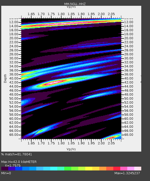
| Estimated Moho Depth: |
42.0 km |
| Estimated Crust Vp/Vs: |
1.76 |
| Assumed Crust Vp: |
6.036 km/s |
| Estimated Crust Vs: |
3.435 km/s |
| Estimated Crust Poisson's Ratio: |
0.26 |
|
| Radial Match: |
81.78041 % |
| Radial Bump: |
354 |
| Transverse Match: |
65.5214 % |
| Transverse Bump: |
400 |
| SOD ConfigId: |
20465011 |
| Insert Time: |
2020-02-01 16:43:20.643 +0000 |
| GWidth: |
2.5 |
| Max Bumps: |
400 |
| Tol: |
0.001 |
|

Signal To Noise
| Channel | StoN | STA | LTA |
| MM:NGU: :HHZ:20200118T16:46:30.829994Z | 8.9558935 | 1.4267447E-6 | 1.593079E-7 |
| MM:NGU: :HHN:20200118T16:46:30.829994Z | 2.9081993 | 6.6812305E-7 | 2.2973771E-7 |
| MM:NGU: :HHE:20200118T16:46:30.829994Z | 3.3403924 | 5.728037E-7 | 1.7147796E-7 |
| Arrivals |
| Ps | 5.6 SECOND |
| PpPs | 18 SECOND |
| PsPs/PpSs | 24 SECOND |


