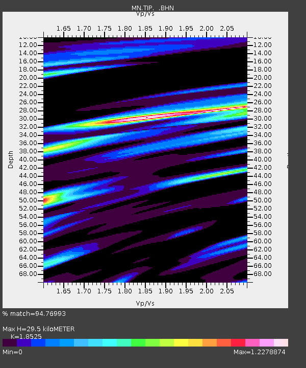
TIP Timpagrande, Italy - Earthquake Result Viewer
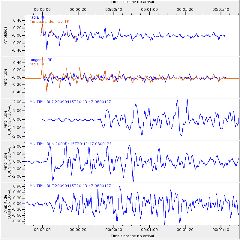
Earthquake location: Southern Sumatra, Indonesia
Earthquake latitude/longitude: -3.1/100.5
Earthquake time(UTC): 2009/04/15 (105) 20:01:34 GMT
Earthquake Depth: 20 km
Earthquake Magnitude: 6.1 MB, 6.4 MS, 6.4 MW, 6.2 MW
Earthquake Catalog/Contributor: WHDF/NEIC
Network: MN MEDNET Project
Station: TIP Timpagrande, Italy
Lat/Lon: 39.18 N/16.76 E
Elevation: 789 m
Distance: 87.1 deg
Az: 309.324 deg
Baz: 96.37 deg
Ray Param: 0.04356939
Estimated Moho Depth: 29.5 km
Estimated Crust Vp/Vs: 1.85
Assumed Crust Vp: 6.1 km/s
Estimated Crust Vs: 3.293 km/s
Estimated Crust Poisson's Ratio: 0.29
Radial Match: 94.76993 %
Radial Bump: 337
Transverse Match: 84.40868 %
Transverse Bump: 400
SOD ConfigId: 2658
Insert Time: 2010-03-08 17:21:35.017 +0000
GWidth: 2.5
Max Bumps: 400
Tol: 0.001

Signal To Noise

ChannelStoNSTALTA
MN:TIP: :BHN:20090415T20:13:47.080012Z13.9803039.565539E-76.842154E-8
MN:TIP: :BHE:20090415T20:13:47.080012Z0.804461665.039978E-86.265032E-8
MN:TIP: :BHZ:20090415T20:13:47.080012Z4.44782453.9140784E-78.799983E-8
Arrivals
Ps4.2 SECOND
PpPs14 SECOND
PsPs/PpSs18 SECOND