You are here: Home > Network List > TA - USArray Transportable Network (new EarthScope stations) Stations List
> Station D25K Kavik River, AK, USA > Earthquake Result Viewer
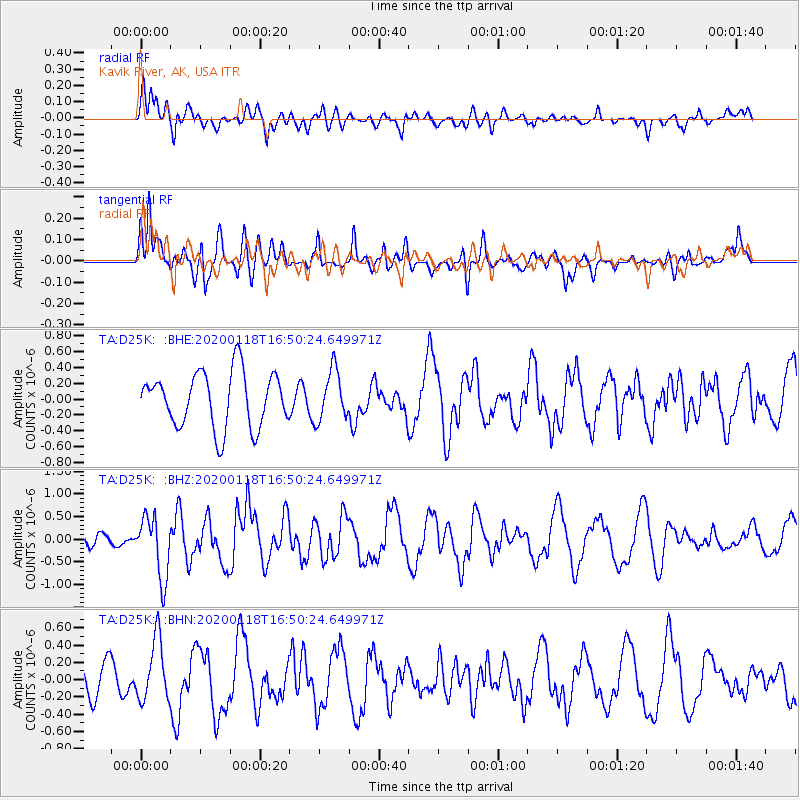
D25K Kavik River, AK, USA - Earthquake Result Viewer
*The percent match for this event was below the threshold and hence no stack was calculated.
| Earthquake location: |
Near North Coast Of Irian Jaya |
| Earthquake latitude/longitude: |
-2.9/139.3 |
| Earthquake time(UTC): |
2020/01/18 (018) 16:38:13 GMT |
| Earthquake Depth: |
34 km |
| Earthquake Magnitude: |
6.0 Mww |
| Earthquake Catalog/Contributor: |
NEIC PDE/us |
|
| Network: |
TA USArray Transportable Network (new EarthScope stations) |
| Station: |
D25K Kavik River, AK, USA |
| Lat/Lon: |
69.32 N/146.38 W |
| Elevation: |
770 m |
|
| Distance: |
87.1 deg |
| Az: |
20.02 deg |
| Baz: |
254.294 deg |
| Ray Param: |
$rayparam |
*The percent match for this event was below the threshold and hence was not used in the summary stack. |
|
| Radial Match: |
61.544853 % |
| Radial Bump: |
400 |
| Transverse Match: |
62.14922 % |
| Transverse Bump: |
400 |
| SOD ConfigId: |
20465011 |
| Insert Time: |
2020-02-01 16:44:34.271 +0000 |
| GWidth: |
2.5 |
| Max Bumps: |
400 |
| Tol: |
0.001 |
|
Signal To Noise
| Channel | StoN | STA | LTA |
| TA:D25K: :BHZ:20200118T16:50:24.649971Z | 2.3766513 | 6.7888374E-7 | 2.856472E-7 |
| TA:D25K: :BHN:20200118T16:50:24.649971Z | 1.6294614 | 3.5964493E-7 | 2.2071399E-7 |
| TA:D25K: :BHE:20200118T16:50:24.649971Z | 0.90634733 | 3.154352E-7 | 3.4802903E-7 |
| Arrivals |
| Ps | |
| PpPs | |
| PsPs/PpSs | |


