You are here: Home > Network List > TA - USArray Transportable Network (new EarthScope stations) Stations List
> Station E20K Nigu River, AK, USA > Earthquake Result Viewer
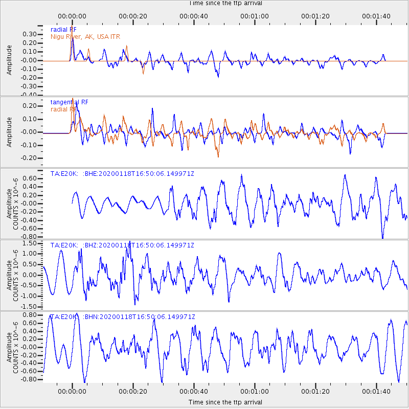
E20K Nigu River, AK, USA - Earthquake Result Viewer
*The percent match for this event was below the threshold and hence no stack was calculated.
| Earthquake location: |
Near North Coast Of Irian Jaya |
| Earthquake latitude/longitude: |
-2.9/139.3 |
| Earthquake time(UTC): |
2020/01/18 (018) 16:38:13 GMT |
| Earthquake Depth: |
34 km |
| Earthquake Magnitude: |
6.0 Mww |
| Earthquake Catalog/Contributor: |
NEIC PDE/us |
|
| Network: |
TA USArray Transportable Network (new EarthScope stations) |
| Station: |
E20K Nigu River, AK, USA |
| Lat/Lon: |
68.26 N/156.19 W |
| Elevation: |
866 m |
|
| Distance: |
83.4 deg |
| Az: |
19.783 deg |
| Baz: |
245.131 deg |
| Ray Param: |
$rayparam |
*The percent match for this event was below the threshold and hence was not used in the summary stack. |
|
| Radial Match: |
52.959244 % |
| Radial Bump: |
400 |
| Transverse Match: |
61.915855 % |
| Transverse Bump: |
396 |
| SOD ConfigId: |
20465011 |
| Insert Time: |
2020-02-01 16:44:37.776 +0000 |
| GWidth: |
2.5 |
| Max Bumps: |
400 |
| Tol: |
0.001 |
|
Signal To Noise
| Channel | StoN | STA | LTA |
| TA:E20K: :BHZ:20200118T16:50:06.149971Z | 1.688635 | 7.188727E-7 | 4.257123E-7 |
| TA:E20K: :BHN:20200118T16:50:06.149971Z | 1.7168831 | 5.8809474E-7 | 3.4253628E-7 |
| TA:E20K: :BHE:20200118T16:50:06.149971Z | 1.6772531 | 2.3841078E-7 | 1.4214359E-7 |
| Arrivals |
| Ps | |
| PpPs | |
| PsPs/PpSs | |


