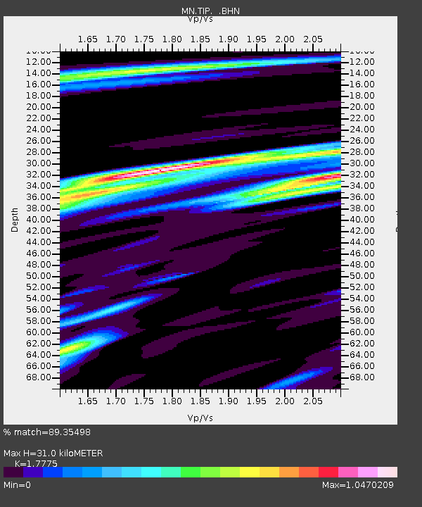
TIP Timpagrande, Italy - Earthquake Result Viewer

Earthquake location: Bonin Islands, Japan Region
Earthquake latitude/longitude: 26.8/142.4
Earthquake time(UTC): 2008/02/27 (058) 06:54:20 GMT
Earthquake Depth: 15 km
Earthquake Magnitude: 5.8 MB, 6.1 MS, 6.2 MW, 6.2 MW
Earthquake Catalog/Contributor: WHDF/NEIC
Network: MN MEDNET Project
Station: TIP Timpagrande, Italy
Lat/Lon: 39.18 N/16.76 E
Elevation: 789 m
Distance: 97.1 deg
Az: 320.494 deg
Baz: 47.009 deg
Ray Param: 0.040326905
Estimated Moho Depth: 31.0 km
Estimated Crust Vp/Vs: 1.78
Assumed Crust Vp: 6.1 km/s
Estimated Crust Vs: 3.432 km/s
Estimated Crust Poisson's Ratio: 0.27
Radial Match: 89.35498 %
Radial Bump: 400
Transverse Match: 77.08206 %
Transverse Bump: 400
SOD ConfigId: 2564
Insert Time: 2010-03-08 17:21:40.896 +0000
GWidth: 2.5
Max Bumps: 400
Tol: 0.001

Signal To Noise

ChannelStoNSTALTA
MN:TIP: :BHN:20080227T07:07:20.02803Z0.89998851.1444158E-71.2715894E-7
MN:TIP: :BHE:20080227T07:07:20.02803Z1.72205592.0186765E-71.1722479E-7
MN:TIP: :BHZ:20080227T07:07:20.02803Z7.73049935.346597E-76.9162375E-8
Arrivals
Ps4.0 SECOND
PpPs14 SECOND
PsPs/PpSs18 SECOND