You are here: Home > Network List > TA - USArray Transportable Network (new EarthScope stations) Stations List
> Station G31M Satah River, YT, CAN > Earthquake Result Viewer
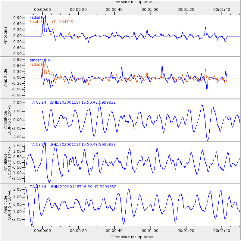
G31M Satah River, YT, CAN - Earthquake Result Viewer
*The percent match for this event was below the threshold and hence no stack was calculated.
| Earthquake location: |
Near North Coast Of Irian Jaya |
| Earthquake latitude/longitude: |
-2.9/139.3 |
| Earthquake time(UTC): |
2020/01/18 (018) 16:38:13 GMT |
| Earthquake Depth: |
34 km |
| Earthquake Magnitude: |
6.0 Mww |
| Earthquake Catalog/Contributor: |
NEIC PDE/us |
|
| Network: |
TA USArray Transportable Network (new EarthScope stations) |
| Station: |
G31M Satah River, YT, CAN |
| Lat/Lon: |
66.92 N/134.27 W |
| Elevation: |
61 m |
|
| Distance: |
91.2 deg |
| Az: |
23.173 deg |
| Baz: |
265.571 deg |
| Ray Param: |
$rayparam |
*The percent match for this event was below the threshold and hence was not used in the summary stack. |
|
| Radial Match: |
68.96665 % |
| Radial Bump: |
400 |
| Transverse Match: |
65.06874 % |
| Transverse Bump: |
400 |
| SOD ConfigId: |
20465011 |
| Insert Time: |
2020-02-01 16:44:58.018 +0000 |
| GWidth: |
2.5 |
| Max Bumps: |
400 |
| Tol: |
0.001 |
|
Signal To Noise
| Channel | StoN | STA | LTA |
| TA:G31M: :BHZ:20200118T16:50:43.599983Z | 3.3690417 | 1.3818135E-6 | 4.101503E-7 |
| TA:G31M: :BHN:20200118T16:50:43.599983Z | 0.7266268 | 7.9538773E-7 | 1.0946302E-6 |
| TA:G31M: :BHE:20200118T16:50:43.599983Z | 1.6592934 | 1.1775479E-6 | 7.0966826E-7 |
| Arrivals |
| Ps | |
| PpPs | |
| PsPs/PpSs | |


