You are here: Home > Network List > TM - Thai Seismic Monitoring Network Stations List
> Station UBPT UBPT Phase1 > Earthquake Result Viewer
UBPT UBPT Phase1 - Earthquake Result Viewer
| Earthquake location: |
Near North Coast Of Irian Jaya |
| Earthquake latitude/longitude: |
-2.9/139.3 |
| Earthquake time(UTC): |
2020/01/18 (018) 16:38:13 GMT |
| Earthquake Depth: |
34 km |
| Earthquake Magnitude: |
6.0 Mww |
| Earthquake Catalog/Contributor: |
NEIC PDE/us |
|
| Network: |
TM Thai Seismic Monitoring Network |
| Station: |
UBPT UBPT Phase1 |
| Lat/Lon: |
15.28 N/105.47 E |
| Elevation: |
120 m |
|
| Distance: |
38.1 deg |
| Az: |
299.248 deg |
| Baz: |
115.452 deg |
| Ray Param: |
0.07573524 |
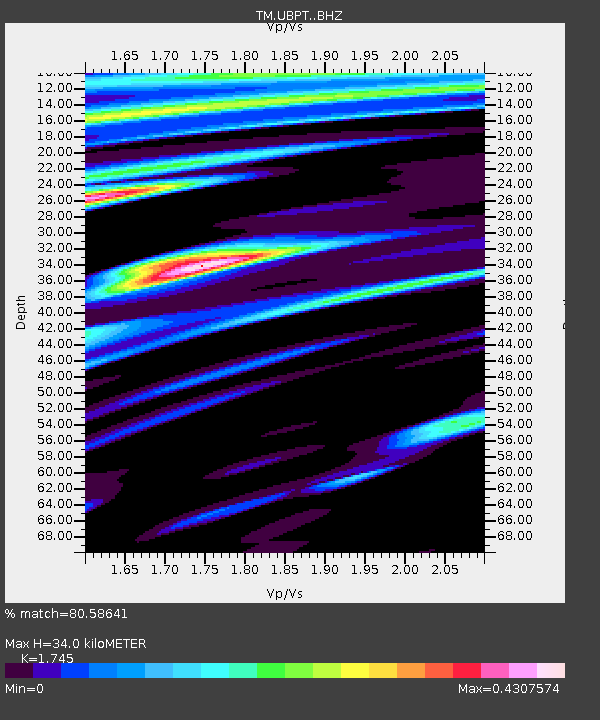
| Estimated Moho Depth: |
34.0 km |
| Estimated Crust Vp/Vs: |
1.75 |
| Assumed Crust Vp: |
6.444 km/s |
| Estimated Crust Vs: |
3.693 km/s |
| Estimated Crust Poisson's Ratio: |
0.26 |
|
| Radial Match: |
80.58641 % |
| Radial Bump: |
400 |
| Transverse Match: |
68.276566 % |
| Transverse Bump: |
400 |
| SOD ConfigId: |
20465011 |
| Insert Time: |
2020-02-01 16:45:48.185 +0000 |
| GWidth: |
2.5 |
| Max Bumps: |
400 |
| Tol: |
0.001 |
|

Signal To Noise
| Channel | StoN | STA | LTA |
| TM:UBPT: :BHZ:20200118T16:44:58.130012Z | 6.3117347 | 1.2143179E-6 | 1.9239052E-7 |
| TM:UBPT: :BHN:20200118T16:44:58.130012Z | 1.6910764 | 1.5636437E-7 | 9.24644E-8 |
| TM:UBPT: :BHE:20200118T16:44:58.130012Z | 4.94163 | 4.741308E-7 | 9.5946234E-8 |
| Arrivals |
| Ps | 4.2 SECOND |
| PpPs | 13 SECOND |
| PsPs/PpSs | 18 SECOND |


