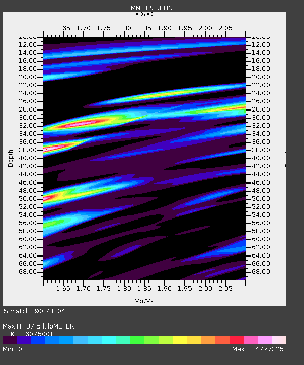
TIP Timpagrande, Italy - Earthquake Result Viewer
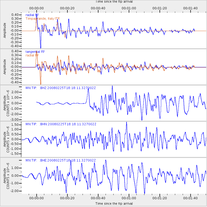
Earthquake location: Southern Sumatra, Indonesia
Earthquake latitude/longitude: -2.3/99.9
Earthquake time(UTC): 2008/02/25 (056) 18:06:03 GMT
Earthquake Depth: 25 km
Earthquake Magnitude: 6.0 MB, 6.4 MS, 6.4 MW, 6.3 MW
Earthquake Catalog/Contributor: WHDF/NEIC
Network: MN MEDNET Project
Station: TIP Timpagrande, Italy
Lat/Lon: 39.18 N/16.76 E
Elevation: 789 m
Distance: 86.1 deg
Az: 309.337 deg
Baz: 96.133 deg
Ray Param: 0.044241246
Estimated Moho Depth: 37.5 km
Estimated Crust Vp/Vs: 1.61
Assumed Crust Vp: 6.1 km/s
Estimated Crust Vs: 3.795 km/s
Estimated Crust Poisson's Ratio: 0.18
Radial Match: 90.78104 %
Radial Bump: 400
Transverse Match: 78.125984 %
Transverse Bump: 400
SOD ConfigId: 2564
Insert Time: 2010-03-08 17:21:43.446 +0000
GWidth: 2.5
Max Bumps: 400
Tol: 0.001

Signal To Noise

ChannelStoNSTALTA
MN:TIP: :BHN:20080225T18:18:11.327002Z1.56406071.9074552E-71.2195532E-7
MN:TIP: :BHE:20080225T18:18:11.327002Z4.4575155.1595606E-71.1574972E-7
MN:TIP: :BHZ:20080225T18:18:11.327002Z8.5047881.0467419E-61.2307677E-7
Arrivals
Ps3.8 SECOND
PpPs16 SECOND
PsPs/PpSs19 SECOND