You are here: Home > Network List > MN - MEDNET Project Stations List
> Station TIP Timpagrande, Italy > Earthquake Result Viewer
TIP Timpagrande, Italy - Earthquake Result Viewer
| Earthquake location: |
Southern Sumatra, Indonesia |
| Earthquake latitude/longitude: |
-4.3/102.7 |
| Earthquake time(UTC): |
2008/04/02 (093) 08:48:49 GMT |
| Earthquake Depth: |
67 km |
| Earthquake Magnitude: |
5.8 MB, 5.7 MW, 5.6 MW |
| Earthquake Catalog/Contributor: |
WHDF/NEIC |
|
| Network: |
MN MEDNET Project |
| Station: |
TIP Timpagrande, Italy |
| Lat/Lon: |
39.18 N/16.76 E |
| Elevation: |
789 m |
|
| Distance: |
89.6 deg |
| Az: |
309.165 deg |
| Baz: |
95.896 deg |
| Ray Param: |
0.041722495 |
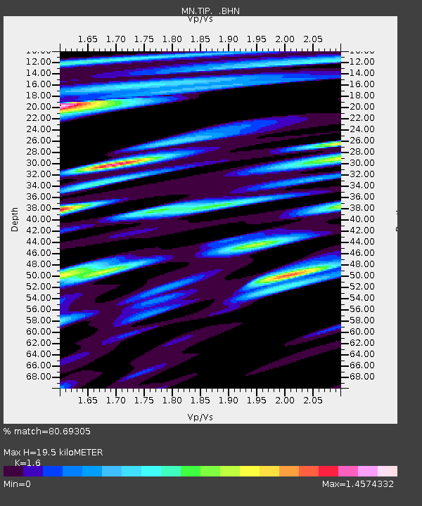
| Estimated Moho Depth: |
19.5 km |
| Estimated Crust Vp/Vs: |
1.60 |
| Assumed Crust Vp: |
6.1 km/s |
| Estimated Crust Vs: |
3.812 km/s |
| Estimated Crust Poisson's Ratio: |
0.18 |
|
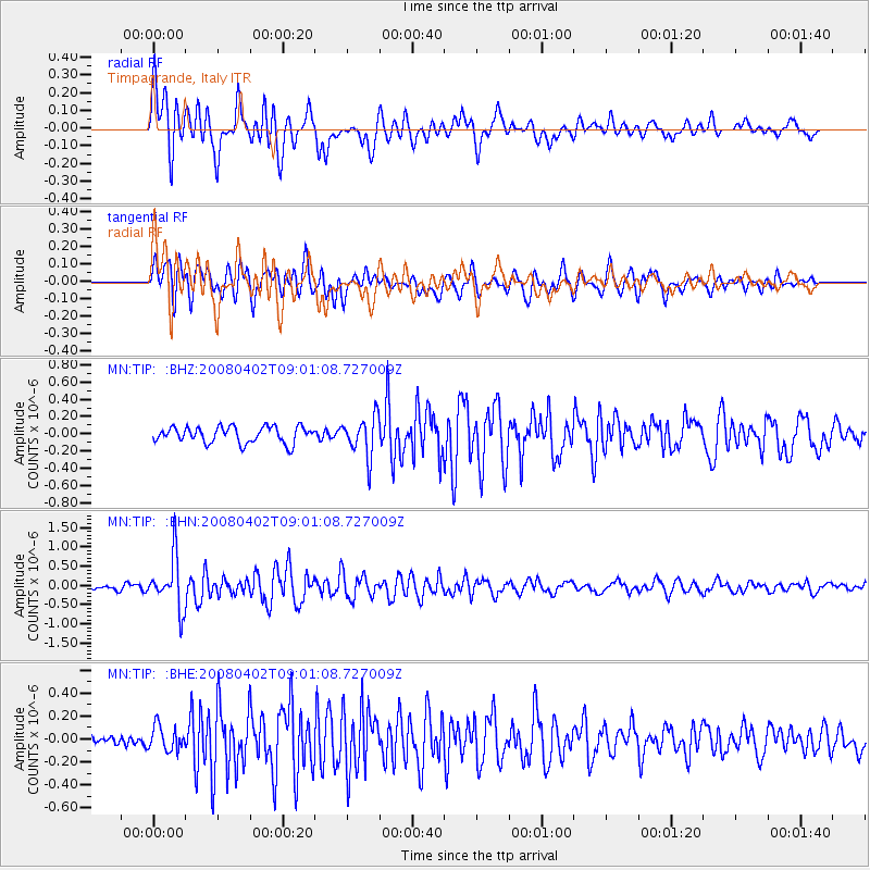
| Radial Match: |
80.69305 % |
| Radial Bump: |
400 |
| Transverse Match: |
65.49656 % |
| Transverse Bump: |
400 |
| SOD ConfigId: |
2504 |
| Insert Time: |
2010-03-08 17:21:48.685 +0000 |
| GWidth: |
2.5 |
| Max Bumps: |
400 |
| Tol: |
0.001 |
|
Signal To Noise
| Channel | StoN | STA | LTA |
| MN:TIP: :BHN:20080402T09:01:08.727009Z | 6.3187323 | 6.6568947E-7 | 1.05351745E-7 |
| MN:TIP: :BHE:20080402T09:01:08.727009Z | 0.84447217 | 1.0635622E-7 | 1.2594401E-7 |
| MN:TIP: :BHZ:20080402T09:01:08.727009Z | 2.4787838 | 2.3197776E-7 | 9.3585314E-8 |
| Arrivals |
| Ps | 2.0 SECOND |
| PpPs | 8.1 SECOND |
| PsPs/PpSs | 10 SECOND |


