You are here: Home > Network List > MN - MEDNET Project Stations List
> Station TIP Timpagrande, Italy > Earthquake Result Viewer
TIP Timpagrande, Italy - Earthquake Result Viewer

| Earthquake location: |
Hokkaido, Japan Region |
| Earthquake latitude/longitude: |
41.5/142.0 |
| Earthquake time(UTC): |
2008/04/29 (120) 05:26:04 GMT |
| Earthquake Depth: |
47 km |
| Earthquake Magnitude: |
5.5 MB, 5.2 MS, 5.8 MW, 5.8 MW |
| Earthquake Catalog/Contributor: |
WHDF/NEIC |
|
| Network: |
MN MEDNET Project |
| Station: |
TIP Timpagrande, Italy |
| Lat/Lon: |
39.18 N/16.76 E |
| Elevation: |
789 m |
|
| Distance: |
85.6 deg |
| Az: |
320.47 deg |
| Baz: |
37.993 deg |
| Ray Param: |
0.044606727 |
| Estimated Moho Depth: |
28.0 km |
| Estimated Crust Vp/Vs: |
2.10 |
| Assumed Crust Vp: |
6.1 km/s |
| Estimated Crust Vs: |
2.908 km/s |
| Estimated Crust Poisson's Ratio: |
0.35 |
|
| Radial Match: |
91.584694 % |
| Radial Bump: |
400 |
| Transverse Match: |
86.6302 % |
| Transverse Bump: |
400 |
| SOD ConfigId: |
2504 |
| Insert Time: |
2010-03-08 17:21:49.913 +0000 |
| GWidth: |
2.5 |
| Max Bumps: |
400 |
| Tol: |
0.001 |
|
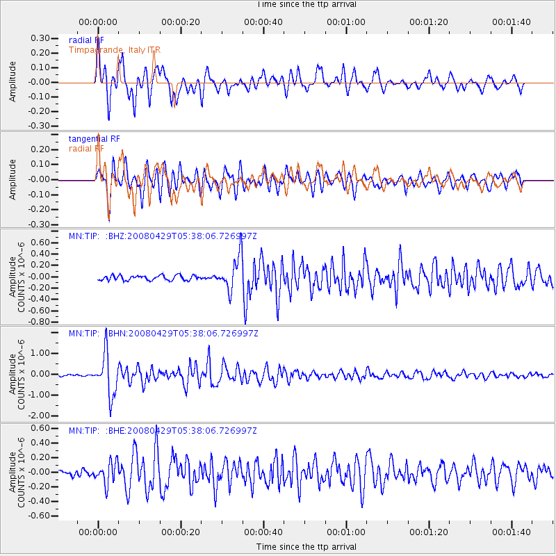
Signal To Noise
| Channel | StoN | STA | LTA |
| MN:TIP: :BHN:20080429T05:38:06.726997Z | 29.380136 | 1.0197635E-6 | 3.4709284E-8 |
| MN:TIP: :BHE:20080429T05:38:06.726997Z | 3.5484638 | 1.5383405E-7 | 4.3352294E-8 |
| MN:TIP: :BHZ:20080429T05:38:06.726997Z | 7.513241 | 3.179245E-7 | 4.2315232E-8 |
| Arrivals |
| Ps | 5.1 SECOND |
| PpPs | 14 SECOND |
| PsPs/PpSs | 19 SECOND |


