You are here: Home > Network List > TA - USArray Transportable Network (new EarthScope stations) Stations List
> Station M14K Bethel, AK, USA > Earthquake Result Viewer
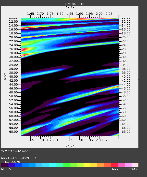
M14K Bethel, AK, USA - Earthquake Result Viewer
| Earthquake location: |
Southern Xinjiang, China |
| Earthquake latitude/longitude: |
39.8/77.1 |
| Earthquake time(UTC): |
2020/01/19 (019) 13:27:56 GMT |
| Earthquake Depth: |
6.3 km |
| Earthquake Magnitude: |
6.0 Mww |
| Earthquake Catalog/Contributor: |
NEIC PDE/us |
|
| Network: |
TA USArray Transportable Network (new EarthScope stations) |
| Station: |
M14K Bethel, AK, USA |
| Lat/Lon: |
60.75 N/161.96 W |
| Elevation: |
19 m |
|
| Distance: |
68.8 deg |
| Az: |
26.858 deg |
| Baz: |
314.896 deg |
| Ray Param: |
0.056070466 |
| Estimated Moho Depth: |
10.0 km |
| Estimated Crust Vp/Vs: |
2.00 |
| Assumed Crust Vp: |
6.182 km/s |
| Estimated Crust Vs: |
3.095 km/s |
| Estimated Crust Poisson's Ratio: |
0.33 |
|
| Radial Match: |
82.62093 % |
| Radial Bump: |
374 |
| Transverse Match: |
72.90135 % |
| Transverse Bump: |
400 |
| SOD ConfigId: |
20465011 |
| Insert Time: |
2020-02-02 13:37:03.467 +0000 |
| GWidth: |
2.5 |
| Max Bumps: |
400 |
| Tol: |
0.001 |
|

Signal To Noise
| Channel | StoN | STA | LTA |
| TA:M14K: :BHZ:20200119T13:38:30.500023Z | 1.9353235 | 2.4005965E-6 | 1.2404109E-6 |
| TA:M14K: :BHN:20200119T13:38:30.500023Z | 0.75957704 | 1.369942E-6 | 1.8035589E-6 |
| TA:M14K: :BHE:20200119T13:38:30.500023Z | 0.8649617 | 1.1456897E-6 | 1.3245555E-6 |
| Arrivals |
| Ps | 1.7 SECOND |
| PpPs | 4.7 SECOND |
| PsPs/PpSs | 6.4 SECOND |


