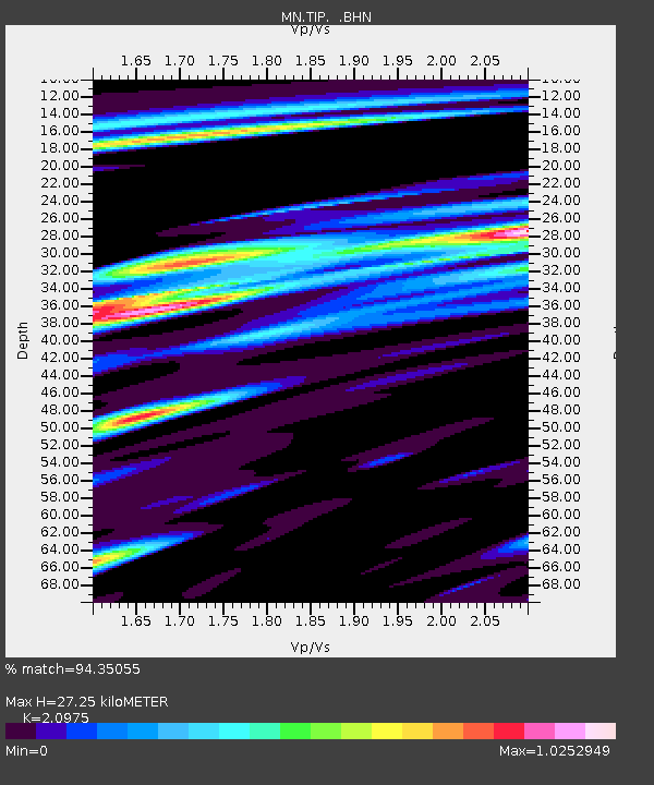
TIP Timpagrande, Italy - Earthquake Result Viewer
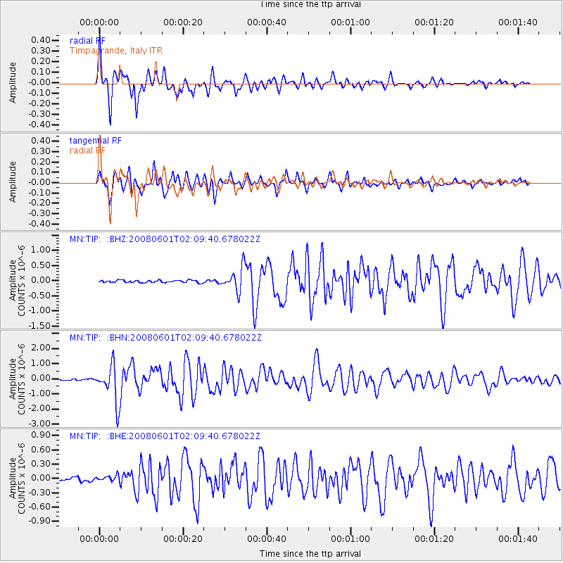
Earthquake location: Philippine Islands Region
Earthquake latitude/longitude: 20.1/121.4
Earthquake time(UTC): 2008/06/01 (153) 01:57:24 GMT
Earthquake Depth: 35 km
Earthquake Magnitude: 6.0 MB, 6.2 MS, 6.3 MW, 6.2 MW
Earthquake Catalog/Contributor: WHDF/NEIC
Network: MN MEDNET Project
Station: TIP Timpagrande, Italy
Lat/Lon: 39.18 N/16.76 E
Elevation: 789 m
Distance: 88.2 deg
Az: 311.195 deg
Baz: 65.467 deg
Ray Param: 0.042698964
Estimated Moho Depth: 27.25 km
Estimated Crust Vp/Vs: 2.10
Assumed Crust Vp: 6.1 km/s
Estimated Crust Vs: 2.908 km/s
Estimated Crust Poisson's Ratio: 0.35
Radial Match: 94.35055 %
Radial Bump: 400
Transverse Match: 92.94607 %
Transverse Bump: 400
SOD ConfigId: 2504
Insert Time: 2010-03-08 17:22:00.755 +0000
GWidth: 2.5
Max Bumps: 400
Tol: 0.001

Signal To Noise

ChannelStoNSTALTA
MN:TIP: :BHN:20080601T02:09:40.678022Z31.4223381.276805E-64.0633676E-8
MN:TIP: :BHE:20080601T02:09:40.678022Z1.23884265.7065286E-84.6063384E-8
MN:TIP: :BHZ:20080601T02:09:40.678022Z10.5415833.9434283E-73.7408313E-8
Arrivals
Ps5.0 SECOND
PpPs14 SECOND
PsPs/PpSs19 SECOND