You are here: Home > Network List > AU - Australian Seismological Centre Stations List
> Station DNDOZ Balladonia, WA > Earthquake Result Viewer
DNDOZ Balladonia, WA - Earthquake Result Viewer
| Earthquake location: |
Minahassa Peninsula, Sulawesi |
| Earthquake latitude/longitude: |
-0.1/123.8 |
| Earthquake time(UTC): |
2020/01/19 (019) 16:58:19 GMT |
| Earthquake Depth: |
121 km |
| Earthquake Magnitude: |
6.1 Mww |
| Earthquake Catalog/Contributor: |
NEIC PDE/us |
|
| Network: |
AU Australian Seismological Centre |
| Station: |
DNDOZ Balladonia, WA |
| Lat/Lon: |
32.46 S/123.87 E |
| Elevation: |
153 m |
|
| Distance: |
32.2 deg |
| Az: |
179.874 deg |
| Baz: |
359.851 deg |
| Ray Param: |
0.078430906 |
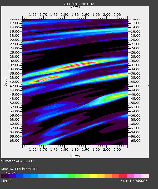
| Estimated Moho Depth: |
38.5 km |
| Estimated Crust Vp/Vs: |
1.71 |
| Assumed Crust Vp: |
6.464 km/s |
| Estimated Crust Vs: |
3.78 km/s |
| Estimated Crust Poisson's Ratio: |
0.24 |
|
| Radial Match: |
84.59937 % |
| Radial Bump: |
400 |
| Transverse Match: |
71.48102 % |
| Transverse Bump: |
400 |
| SOD ConfigId: |
20465011 |
| Insert Time: |
2020-02-02 16:59:55.077 +0000 |
| GWidth: |
2.5 |
| Max Bumps: |
400 |
| Tol: |
0.001 |
|

Signal To Noise
| Channel | StoN | STA | LTA |
| AU:DNDOZ:00:HHZ:20200119T17:04:06.004989Z | 5.451202 | 5.1030606E-6 | 9.3613494E-7 |
| AU:DNDOZ:00:HHN:20200119T17:04:06.004989Z | 3.0732927 | 2.6922314E-6 | 8.760088E-7 |
| AU:DNDOZ:00:HHE:20200119T17:04:06.004989Z | 1.0957175 | 6.898359E-7 | 6.295745E-7 |
| Arrivals |
| Ps | 4.6 SECOND |
| PpPs | 15 SECOND |
| PsPs/PpSs | 19 SECOND |


