You are here: Home > Network List > MN - MEDNET Project Stations List
> Station TIP Timpagrande, Italy > Earthquake Result Viewer
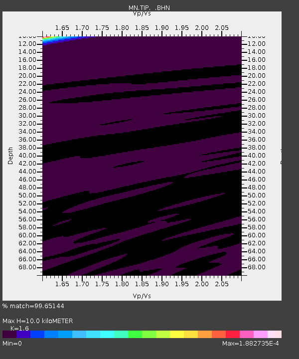
TIP Timpagrande, Italy - Earthquake Result Viewer
| Earthquake location: |
Guatemala |
| Earthquake latitude/longitude: |
14.1/-91.5 |
| Earthquake time(UTC): |
2008/01/05 (005) 01:56:45 GMT |
| Earthquake Depth: |
66 km |
| Earthquake Magnitude: |
5.6 MW, 5.4 MB, 5.6 MW |
| Earthquake Catalog/Contributor: |
WHDF/NEIC |
|
| Network: |
MN MEDNET Project |
| Station: |
TIP Timpagrande, Italy |
| Lat/Lon: |
39.18 N/16.76 E |
| Elevation: |
789 m |
|
| Distance: |
94.8 deg |
| Az: |
47.798 deg |
| Baz: |
292.389 deg |
| Ray Param: |
0.04091449 |
| Estimated Moho Depth: |
10.0 km |
| Estimated Crust Vp/Vs: |
1.60 |
| Assumed Crust Vp: |
6.1 km/s |
| Estimated Crust Vs: |
3.812 km/s |
| Estimated Crust Poisson's Ratio: |
0.18 |
|
| Radial Match: |
99.65144 % |
| Radial Bump: |
43 |
| Transverse Match: |
99.968796 % |
| Transverse Bump: |
4 |
| SOD ConfigId: |
2564 |
| Insert Time: |
2010-03-08 17:22:14.772 +0000 |
| GWidth: |
2.5 |
| Max Bumps: |
400 |
| Tol: |
0.001 |
|

Signal To Noise
| Channel | StoN | STA | LTA |
| MN:TIP: :BHN:20080105T02:09:28.436013Z | 1.0607091 | 9.659651E-7 | 9.106786E-7 |
| MN:TIP: :BHE:20080105T02:09:28.436013Z | 0.663979 | 4.017732E-7 | 6.050993E-7 |
| MN:TIP: :BHZ:20080105T02:09:28.436013Z | 0.8047988 | 6.119968E-7 | 7.6043455E-7 |
| Arrivals |
| Ps | 1.0 SECOND |
| PpPs | 4.2 SECOND |
| PsPs/PpSs | 5.2 SECOND |


