You are here: Home > Network List > GS - US Geological Survey Networks Stations List
> Station OK031 S. Brethren Rd., Cushing, OK, USA > Earthquake Result Viewer
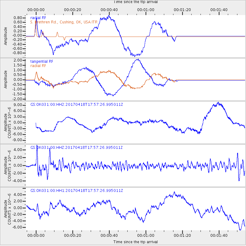
OK031 S. Brethren Rd., Cushing, OK, USA - Earthquake Result Viewer
*The percent match for this event was below the threshold and hence no stack was calculated.
| Earthquake location: |
Peru-Ecuador Border Region |
| Earthquake latitude/longitude: |
-2.7/-75.3 |
| Earthquake time(UTC): |
2017/04/18 (108) 17:49:55 GMT |
| Earthquake Depth: |
11 km |
| Earthquake Magnitude: |
6.0 Mww |
| Earthquake Catalog/Contributor: |
NEIC PDE/us |
|
| Network: |
GS US Geological Survey Networks |
| Station: |
OK031 S. Brethren Rd., Cushing, OK, USA |
| Lat/Lon: |
35.95 N/96.84 W |
| Elevation: |
290 m |
|
| Distance: |
43.4 deg |
| Az: |
334.327 deg |
| Baz: |
147.767 deg |
| Ray Param: |
$rayparam |
*The percent match for this event was below the threshold and hence was not used in the summary stack. |
|
| Radial Match: |
43.61271 % |
| Radial Bump: |
400 |
| Transverse Match: |
26.66039 % |
| Transverse Bump: |
400 |
| SOD ConfigId: |
2028011 |
| Insert Time: |
2017-05-02 17:54:27.571 +0000 |
| GWidth: |
2.5 |
| Max Bumps: |
400 |
| Tol: |
0.001 |
|
Signal To Noise
| Channel | StoN | STA | LTA |
| GS:OK031:00:HHZ:20170418T17:57:26.995011Z | 12.17726 | 1.8383752E-6 | 1.5096788E-7 |
| GS:OK031:00:HH1:20170418T17:57:26.995011Z | 0.80134666 | 1.2216425E-6 | 1.524487E-6 |
| GS:OK031:00:HH2:20170418T17:57:26.995011Z | 0.99821985 | 2.603549E-6 | 2.608192E-6 |
| Arrivals |
| Ps | |
| PpPs | |
| PsPs/PpSs | |


