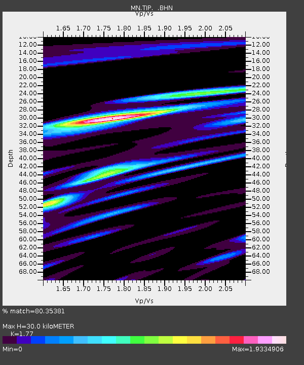
TIP Timpagrande, Italy - Earthquake Result Viewer
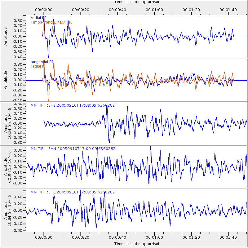
Earthquake location: Northern Sumatra, Indonesia
Earthquake latitude/longitude: 4.9/95.0
Earthquake time(UTC): 2005/09/10 (253) 16:57:47 GMT
Earthquake Depth: 41 km
Earthquake Magnitude: 5.8 MB, 5.5 MS, 5.8 MW, 5.8 MW
Earthquake Catalog/Contributor: WHDF/NEIC
Network: MN MEDNET Project
Station: TIP Timpagrande, Italy
Lat/Lon: 39.18 N/16.76 E
Elevation: 789 m
Distance: 77.9 deg
Az: 308.881 deg
Baz: 93.627 deg
Ray Param: 0.04996512
Estimated Moho Depth: 30.0 km
Estimated Crust Vp/Vs: 1.77
Assumed Crust Vp: 6.1 km/s
Estimated Crust Vs: 3.446 km/s
Estimated Crust Poisson's Ratio: 0.27
Radial Match: 80.35381 %
Radial Bump: 400
Transverse Match: 65.22057 %
Transverse Bump: 400
SOD ConfigId: 2669
Insert Time: 2010-03-08 17:22:16.543 +0000
GWidth: 2.5
Max Bumps: 400
Tol: 0.001

Signal To Noise

ChannelStoNSTALTA
MN:TIP: :BHN:20050910T17:09:09.636028Z0.637537966.199631E-89.724333E-8
MN:TIP: :BHE:20050910T17:09:09.636028Z1.69493911.3451756E-77.936425E-8
MN:TIP: :BHZ:20050910T17:09:09.636028Z5.56209852.939871E-75.285543E-8
Arrivals
Ps3.9 SECOND
PpPs13 SECOND
PsPs/PpSs17 SECOND