You are here: Home > Network List > G - GEOSCOPE Stations List
> Station RER Riviere de l'Est, La Reunion (Indian Ocean) > Earthquake Result Viewer
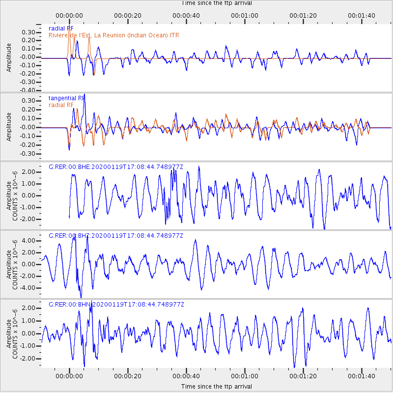
RER Riviere de l'Est, La Reunion (Indian Ocean) - Earthquake Result Viewer
*The percent match for this event was below the threshold and hence no stack was calculated.
| Earthquake location: |
Minahassa Peninsula, Sulawesi |
| Earthquake latitude/longitude: |
-0.1/123.8 |
| Earthquake time(UTC): |
2020/01/19 (019) 16:58:19 GMT |
| Earthquake Depth: |
121 km |
| Earthquake Magnitude: |
6.1 Mww |
| Earthquake Catalog/Contributor: |
NEIC PDE/us |
|
| Network: |
G GEOSCOPE |
| Station: |
RER Riviere de l'Est, La Reunion (Indian Ocean) |
| Lat/Lon: |
21.16 S/55.75 E |
| Elevation: |
834 m |
|
| Distance: |
69.5 deg |
| Az: |
247.521 deg |
| Baz: |
81.873 deg |
| Ray Param: |
$rayparam |
*The percent match for this event was below the threshold and hence was not used in the summary stack. |
|
| Radial Match: |
57.594032 % |
| Radial Bump: |
400 |
| Transverse Match: |
52.54563 % |
| Transverse Bump: |
400 |
| SOD ConfigId: |
20465011 |
| Insert Time: |
2020-02-02 17:01:31.025 +0000 |
| GWidth: |
2.5 |
| Max Bumps: |
400 |
| Tol: |
0.001 |
|
Signal To Noise
| Channel | StoN | STA | LTA |
| G:RER:00:BHZ:20200119T17:08:44.748977Z | 2.1745508 | 3.2778928E-6 | 1.5073884E-6 |
| G:RER:00:BHN:20200119T17:08:44.748977Z | 0.77563673 | 1.0367339E-6 | 1.3366231E-6 |
| G:RER:00:BHE:20200119T17:08:44.748977Z | 1.0589836 | 1.1607585E-6 | 1.0961062E-6 |
| Arrivals |
| Ps | |
| PpPs | |
| PsPs/PpSs | |


