You are here: Home > Network List > GO - National Seismic Network of Georgia Stations List
> Station TBLG Delisi, Georgia > Earthquake Result Viewer
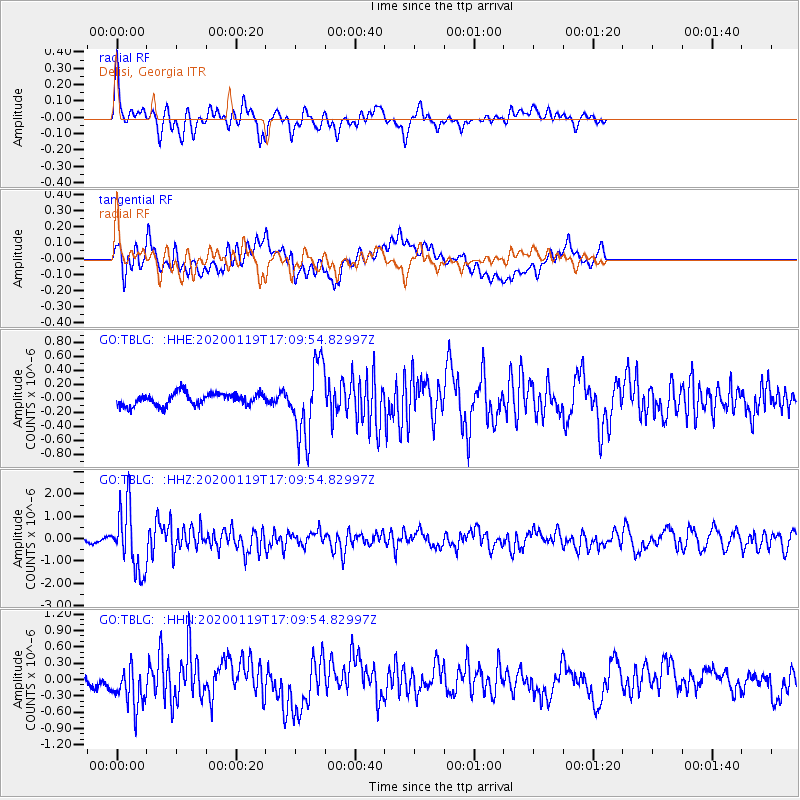
TBLG Delisi, Georgia - Earthquake Result Viewer
*The percent match for this event was below the threshold and hence no stack was calculated.
| Earthquake location: |
Minahassa Peninsula, Sulawesi |
| Earthquake latitude/longitude: |
-0.1/123.8 |
| Earthquake time(UTC): |
2020/01/19 (019) 16:58:19 GMT |
| Earthquake Depth: |
121 km |
| Earthquake Magnitude: |
6.1 Mww |
| Earthquake Catalog/Contributor: |
NEIC PDE/us |
|
| Network: |
GO National Seismic Network of Georgia |
| Station: |
TBLG Delisi, Georgia |
| Lat/Lon: |
41.73 N/44.74 E |
| Elevation: |
510 m |
|
| Distance: |
81.9 deg |
| Az: |
312.074 deg |
| Baz: |
97.391 deg |
| Ray Param: |
$rayparam |
*The percent match for this event was below the threshold and hence was not used in the summary stack. |
|
| Radial Match: |
73.80747 % |
| Radial Bump: |
400 |
| Transverse Match: |
63.833908 % |
| Transverse Bump: |
400 |
| SOD ConfigId: |
20465011 |
| Insert Time: |
2020-02-02 17:01:40.747 +0000 |
| GWidth: |
2.5 |
| Max Bumps: |
400 |
| Tol: |
0.001 |
|
Signal To Noise
| Channel | StoN | STA | LTA |
| GO:TBLG: :HHZ:20200119T17:09:54.82997Z | 11.237418 | 1.4158338E-6 | 1.259928E-7 |
| GO:TBLG: :HHN:20200119T17:09:54.82997Z | 2.2734168 | 3.822676E-7 | 1.6814673E-7 |
| GO:TBLG: :HHE:20200119T17:09:54.82997Z | 5.852789 | 5.2336924E-7 | 8.9422194E-8 |
| Arrivals |
| Ps | |
| PpPs | |
| PsPs/PpSs | |


