You are here: Home > Network List > MN - MEDNET Project Stations List
> Station TIP Timpagrande, Italy > Earthquake Result Viewer
TIP Timpagrande, Italy - Earthquake Result Viewer
| Earthquake location: |
Kuril Islands |
| Earthquake latitude/longitude: |
47.0/153.9 |
| Earthquake time(UTC): |
2005/08/01 (213) 04:40:36 GMT |
| Earthquake Depth: |
17 km |
| Earthquake Magnitude: |
5.4 MB, 5.1 MS, 5.7 MW, 5.7 MW |
| Earthquake Catalog/Contributor: |
WHDF/NEIC |
|
| Network: |
MN MEDNET Project |
| Station: |
TIP Timpagrande, Italy |
| Lat/Lon: |
39.18 N/16.76 E |
| Elevation: |
789 m |
|
| Distance: |
86.1 deg |
| Az: |
328.007 deg |
| Baz: |
27.814 deg |
| Ray Param: |
0.04430474 |
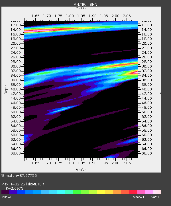
| Estimated Moho Depth: |
32.25 km |
| Estimated Crust Vp/Vs: |
2.10 |
| Assumed Crust Vp: |
6.1 km/s |
| Estimated Crust Vs: |
2.908 km/s |
| Estimated Crust Poisson's Ratio: |
0.35 |
|
| Radial Match: |
87.57756 % |
| Radial Bump: |
400 |
| Transverse Match: |
79.20574 % |
| Transverse Bump: |
400 |
| SOD ConfigId: |
2422 |
| Insert Time: |
2010-03-08 17:22:22.655 +0000 |
| GWidth: |
2.5 |
| Max Bumps: |
400 |
| Tol: |
0.001 |
|

Signal To Noise
| Channel | StoN | STA | LTA |
| MN:TIP: :BHN:20050801T04:52:44.886025Z | 3.0867357 | 1.2707667E-7 | 4.116863E-8 |
| MN:TIP: :BHE:20050801T04:52:44.886025Z | 2.272538 | 1.1944822E-7 | 5.2561592E-8 |
| MN:TIP: :BHZ:20050801T04:52:44.886025Z | 7.0780497 | 4.0496573E-7 | 5.721431E-8 |
| Arrivals |
| Ps | 5.9 SECOND |
| PpPs | 16 SECOND |
| PsPs/PpSs | 22 SECOND |


