You are here: Home > Network List > MN - MEDNET Project Stations List
> Station TIP Timpagrande, Italy > Earthquake Result Viewer
TIP Timpagrande, Italy - Earthquake Result Viewer
| Earthquake location: |
Off W Coast Of Northern Sumatra |
| Earthquake latitude/longitude: |
2.9/93.6 |
| Earthquake time(UTC): |
2005/07/29 (210) 20:33:40 GMT |
| Earthquake Depth: |
32 km |
| Earthquake Magnitude: |
5.8 MB, 5.0 MS, 5.5 MW |
| Earthquake Catalog/Contributor: |
WHDF/NEIC |
|
| Network: |
MN MEDNET Project |
| Station: |
TIP Timpagrande, Italy |
| Lat/Lon: |
39.18 N/16.76 E |
| Elevation: |
789 m |
|
| Distance: |
78.0 deg |
| Az: |
309.313 deg |
| Baz: |
96.164 deg |
| Ray Param: |
0.049915347 |
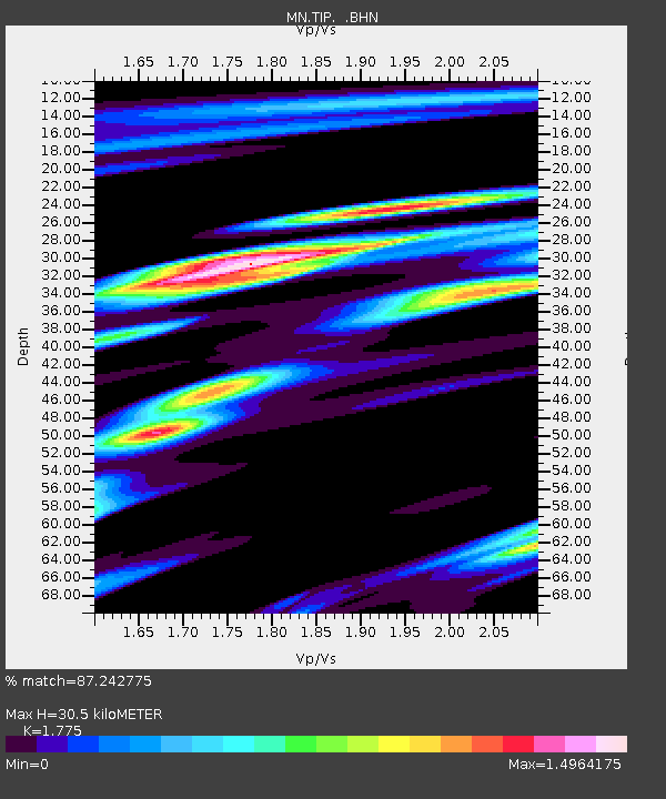
| Estimated Moho Depth: |
30.5 km |
| Estimated Crust Vp/Vs: |
1.77 |
| Assumed Crust Vp: |
6.1 km/s |
| Estimated Crust Vs: |
3.437 km/s |
| Estimated Crust Poisson's Ratio: |
0.27 |
|
| Radial Match: |
87.242775 % |
| Radial Bump: |
400 |
| Transverse Match: |
63.494415 % |
| Transverse Bump: |
400 |
| SOD ConfigId: |
2422 |
| Insert Time: |
2010-03-08 17:22:23.792 +0000 |
| GWidth: |
2.5 |
| Max Bumps: |
400 |
| Tol: |
0.001 |
|
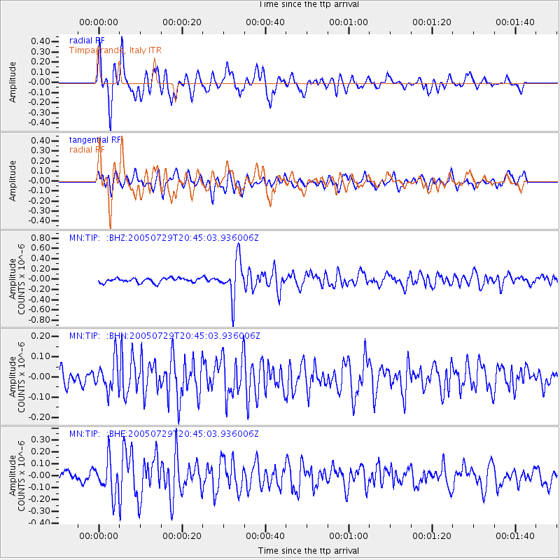
Signal To Noise
| Channel | StoN | STA | LTA |
| MN:TIP: :BHN:20050729T20:45:03.936006Z | 1.7620859 | 7.709764E-8 | 4.3753623E-8 |
| MN:TIP: :BHE:20050729T20:45:03.936006Z | 4.5496774 | 1.4758542E-7 | 3.2438656E-8 |
| MN:TIP: :BHZ:20050729T20:45:03.936006Z | 8.718388 | 3.8174994E-7 | 4.378676E-8 |
| Arrivals |
| Ps | 4.0 SECOND |
| PpPs | 14 SECOND |
| PsPs/PpSs | 17 SECOND |


