You are here: Home > Network List > MN - MEDNET Project Stations List
> Station TIP Timpagrande, Italy > Earthquake Result Viewer
TIP Timpagrande, Italy - Earthquake Result Viewer
| Earthquake location: |
Kyushu, Japan |
| Earthquake latitude/longitude: |
31.0/130.0 |
| Earthquake time(UTC): |
2005/11/21 (325) 15:36:30 GMT |
| Earthquake Depth: |
145 km |
| Earthquake Magnitude: |
5.9 MB, 6.2 MW, 6.2 MW |
| Earthquake Catalog/Contributor: |
WHDF/NEIC |
|
| Network: |
MN MEDNET Project |
| Station: |
TIP Timpagrande, Italy |
| Lat/Lon: |
39.18 N/16.76 E |
| Elevation: |
789 m |
|
| Distance: |
86.6 deg |
| Az: |
314.32 deg |
| Baz: |
52.21 deg |
| Ray Param: |
0.043609414 |
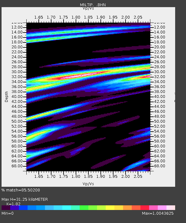
| Estimated Moho Depth: |
31.25 km |
| Estimated Crust Vp/Vs: |
1.82 |
| Assumed Crust Vp: |
6.1 km/s |
| Estimated Crust Vs: |
3.352 km/s |
| Estimated Crust Poisson's Ratio: |
0.28 |
|
| Radial Match: |
85.50208 % |
| Radial Bump: |
400 |
| Transverse Match: |
84.78666 % |
| Transverse Bump: |
400 |
| SOD ConfigId: |
2448 |
| Insert Time: |
2010-03-08 17:22:26.360 +0000 |
| GWidth: |
2.5 |
| Max Bumps: |
400 |
| Tol: |
0.001 |
|
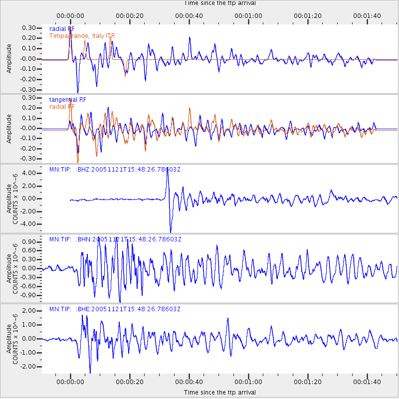
Signal To Noise
| Channel | StoN | STA | LTA |
| MN:TIP: :BHN:20051121T15:48:26.78603Z | 2.804157 | 2.9299716E-7 | 1.04486716E-7 |
| MN:TIP: :BHE:20051121T15:48:26.78603Z | 7.5522294 | 6.650482E-7 | 8.8059856E-8 |
| MN:TIP: :BHZ:20051121T15:48:26.78603Z | 29.375038 | 2.2996664E-6 | 7.828641E-8 |
| Arrivals |
| Ps | 4.3 SECOND |
| PpPs | 14 SECOND |
| PsPs/PpSs | 18 SECOND |


