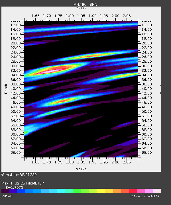
TIP Timpagrande, Italy - Earthquake Result Viewer
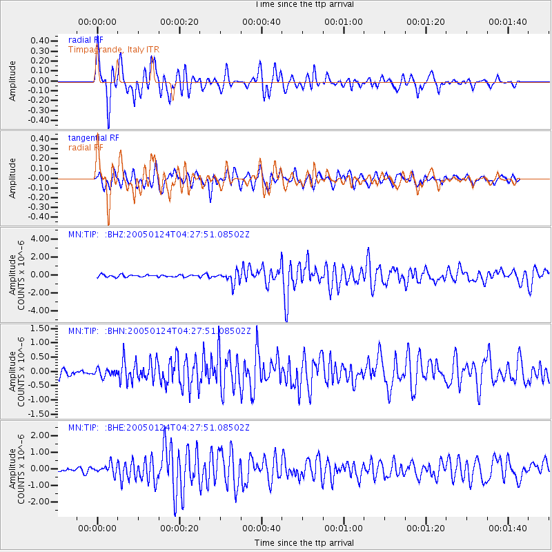
Earthquake location: Nicobar Islands, India Region
Earthquake latitude/longitude: 7.3/92.5
Earthquake time(UTC): 2005/01/24 (024) 04:16:47 GMT
Earthquake Depth: 30 km
Earthquake Magnitude: 6.1 MB, 6.2 MS, 6.3 MW, 6.2 MW
Earthquake Catalog/Contributor: WHDF/NEIC
Network: MN MEDNET Project
Station: TIP Timpagrande, Italy
Lat/Lon: 39.18 N/16.76 E
Elevation: 789 m
Distance: 74.3 deg
Az: 308.532 deg
Baz: 93.298 deg
Ray Param: 0.052355554
Estimated Moho Depth: 32.25 km
Estimated Crust Vp/Vs: 1.71
Assumed Crust Vp: 6.1 km/s
Estimated Crust Vs: 3.572 km/s
Estimated Crust Poisson's Ratio: 0.24
Radial Match: 88.21339 %
Radial Bump: 400
Transverse Match: 79.73311 %
Transverse Bump: 400
SOD ConfigId: 5233
Insert Time: 2010-03-08 17:22:32.384 +0000
GWidth: 2.5
Max Bumps: 400
Tol: 0.001

Signal To Noise

ChannelStoNSTALTA
MN:TIP: :BHN:20050124T04:27:51.08502Z1.19008271.3308446E-71.1182791E-7
MN:TIP: :BHE:20050124T04:27:51.08502Z2.81588462.956241E-71.04984444E-7
MN:TIP: :BHZ:20050124T04:27:51.08502Z5.9399966.8531625E-71.1537318E-7
Arrivals
Ps3.9 SECOND
PpPs14 SECOND
PsPs/PpSs18 SECOND