You are here: Home > Network List > MN - MEDNET Project Stations List
> Station TIP Timpagrande, Italy > Earthquake Result Viewer
TIP Timpagrande, Italy - Earthquake Result Viewer
| Earthquake location: |
Southern Iran |
| Earthquake latitude/longitude: |
27.1/61.9 |
| Earthquake time(UTC): |
2005/03/13 (072) 03:31:23 GMT |
| Earthquake Depth: |
54 km |
| Earthquake Magnitude: |
5.9 MB, 5.4 MS, 6.0 MW, 6.0 MW |
| Earthquake Catalog/Contributor: |
WHDF/NEIC |
|
| Network: |
MN MEDNET Project |
| Station: |
TIP Timpagrande, Italy |
| Lat/Lon: |
39.18 N/16.76 E |
| Elevation: |
789 m |
|
| Distance: |
39.3 deg |
| Az: |
299.545 deg |
| Baz: |
93.919 deg |
| Ray Param: |
0.07492659 |
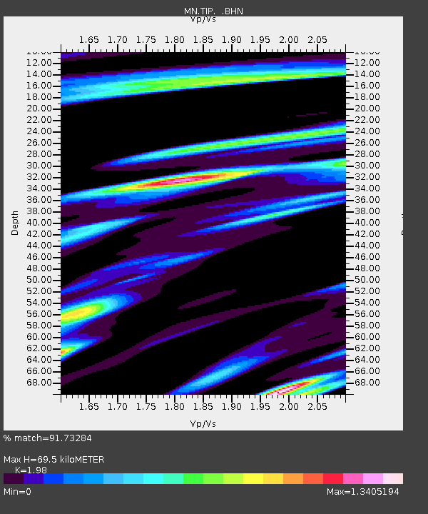
| Estimated Moho Depth: |
69.5 km |
| Estimated Crust Vp/Vs: |
1.98 |
| Assumed Crust Vp: |
6.1 km/s |
| Estimated Crust Vs: |
3.081 km/s |
| Estimated Crust Poisson's Ratio: |
0.33 |
|
| Radial Match: |
91.73284 % |
| Radial Bump: |
400 |
| Transverse Match: |
74.9634 % |
| Transverse Bump: |
400 |
| SOD ConfigId: |
2455 |
| Insert Time: |
2010-03-08 17:22:33.709 +0000 |
| GWidth: |
2.5 |
| Max Bumps: |
400 |
| Tol: |
0.001 |
|

Signal To Noise
| Channel | StoN | STA | LTA |
| MN:TIP: :BHN:20050313T03:38:16.336005Z | 1.3548295 | 2.5108886E-7 | 1.8532874E-7 |
| MN:TIP: :BHE:20050313T03:38:16.336005Z | 5.9884176 | 8.238776E-7 | 1.3757851E-7 |
| MN:TIP: :BHZ:20050313T03:38:16.336005Z | 7.4354763 | 1.4706106E-6 | 1.9778297E-7 |
| Arrivals |
| Ps | 12 SECOND |
| PpPs | 32 SECOND |
| PsPs/PpSs | 44 SECOND |


