TIP Timpagrande, Italy - Earthquake Result Viewer
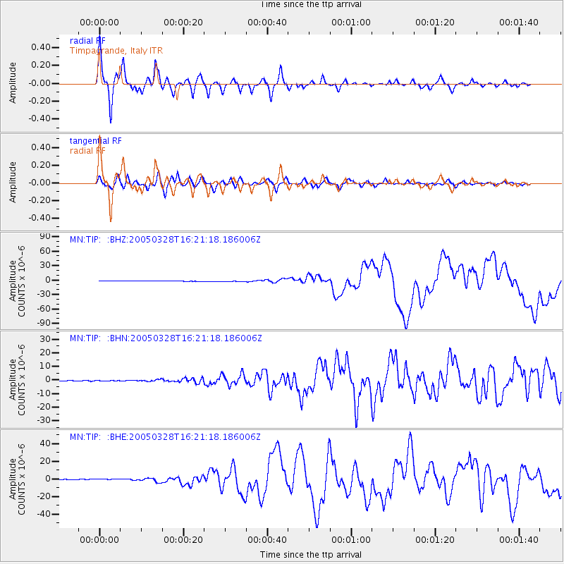
Earthquake location: Northern Sumatra, Indonesia
Earthquake latitude/longitude: 2.1/97.1
Earthquake time(UTC): 2005/03/28 (087) 16:09:36 GMT
Earthquake Depth: 30 km
Earthquake Magnitude: 7.2 MB, 8.4 MS, 8.7 MW, 8.1 MW
Earthquake Catalog/Contributor: WHDF/NEIC
Network: MN MEDNET Project
Station: TIP Timpagrande, Italy
Lat/Lon: 39.18 N/16.76 E
Elevation: 789 m
Distance: 81.2 deg
Az: 309.162 deg
Baz: 94.487 deg
Ray Param: 0.047713187
Estimated Moho Depth: 29.0 km
Estimated Crust Vp/Vs: 1.88
Assumed Crust Vp: 6.1 km/s
Estimated Crust Vs: 3.249 km/s
Estimated Crust Poisson's Ratio: 0.30
Radial Match: 93.74898 %
Radial Bump: 400
Transverse Match: 83.88492 %
Transverse Bump: 400
SOD ConfigId: 2459
Insert Time: 2010-03-08 17:22:35.335 +0000
GWidth: 2.5
Max Bumps: 400
Tol: 0.001

Signal To Noise

ChannelStoNSTALTA
MN:TIP: :BHN:20050328T16:21:18.186006Z0.58497631.3212608E-72.2586566E-7
MN:TIP: :BHE:20050328T16:21:18.186006Z2.00175863.4043154E-71.7006623E-7
MN:TIP: :BHZ:20050328T16:21:18.186006Z2.76326666.6413435E-72.4034392E-7
Arrivals
Ps4.3 SECOND
PpPs13 SECOND
PsPs/PpSs18 SECOND