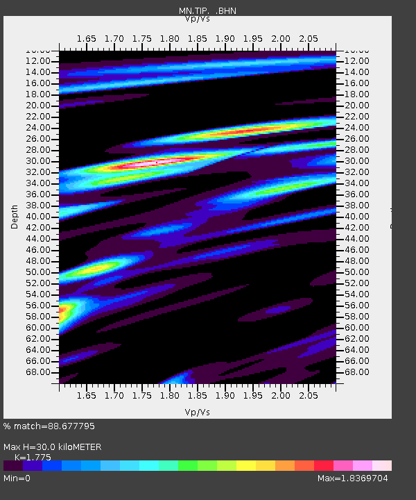
TIP Timpagrande, Italy - Earthquake Result Viewer

Earthquake location: Off W Coast Of Northern Sumatra
Earthquake latitude/longitude: 3.0/95.4
Earthquake time(UTC): 2005/03/30 (089) 16:19:41 GMT
Earthquake Depth: 22 km
Earthquake Magnitude: 5.9 MB, 6.2 MS, 6.4 MW, 6.3 MW
Earthquake Catalog/Contributor: WHDF/NEIC
Network: MN MEDNET Project
Station: TIP Timpagrande, Italy
Lat/Lon: 39.18 N/16.76 E
Elevation: 789 m
Distance: 79.3 deg
Az: 309.15 deg
Baz: 94.862 deg
Ray Param: 0.049018826
Estimated Moho Depth: 30.0 km
Estimated Crust Vp/Vs: 1.77
Assumed Crust Vp: 6.1 km/s
Estimated Crust Vs: 3.437 km/s
Estimated Crust Poisson's Ratio: 0.27
Radial Match: 88.677795 %
Radial Bump: 400
Transverse Match: 78.261444 %
Transverse Bump: 400
SOD ConfigId: 2459
Insert Time: 2010-03-08 17:22:36.515 +0000
GWidth: 2.5
Max Bumps: 400
Tol: 0.001

Signal To Noise

ChannelStoNSTALTA
MN:TIP: :BHN:20050330T16:31:13.636011Z1.16376155.0276448E-84.320168E-8
MN:TIP: :BHE:20050330T16:31:13.636011Z6.56184772.3160008E-73.5294953E-8
MN:TIP: :BHZ:20050330T16:31:13.636011Z13.6986525.254586E-73.8358415E-8
Arrivals
Ps3.9 SECOND
PpPs13 SECOND
PsPs/PpSs17 SECOND