You are here: Home > Network List > PF - Volcanologic Network of Piton de Fournaise-OVPF Stations List
> Station GPS Grandes Pentes Sud > Earthquake Result Viewer
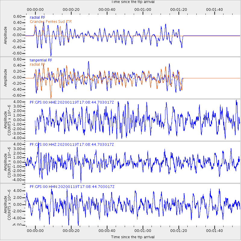
GPS Grandes Pentes Sud - Earthquake Result Viewer
*The percent match for this event was below the threshold and hence no stack was calculated.
| Earthquake location: |
Minahassa Peninsula, Sulawesi |
| Earthquake latitude/longitude: |
-0.1/123.8 |
| Earthquake time(UTC): |
2020/01/19 (019) 16:58:19 GMT |
| Earthquake Depth: |
121 km |
| Earthquake Magnitude: |
6.1 Mww |
| Earthquake Catalog/Contributor: |
NEIC PDE/us |
|
| Network: |
PF Volcanologic Network of Piton de Fournaise-OVPF |
| Station: |
GPS Grandes Pentes Sud |
| Lat/Lon: |
21.27 S/55.76 E |
| Elevation: |
1004 m |
|
| Distance: |
69.5 deg |
| Az: |
247.405 deg |
| Baz: |
81.827 deg |
| Ray Param: |
$rayparam |
*The percent match for this event was below the threshold and hence was not used in the summary stack. |
|
| Radial Match: |
58.97414 % |
| Radial Bump: |
400 |
| Transverse Match: |
50.60185 % |
| Transverse Bump: |
400 |
| SOD ConfigId: |
20465011 |
| Insert Time: |
2020-02-02 17:04:11.883 +0000 |
| GWidth: |
2.5 |
| Max Bumps: |
400 |
| Tol: |
0.001 |
|
Signal To Noise
| Channel | StoN | STA | LTA |
| PF:GPS:00:HHZ:20200119T17:08:44.703017Z | 2.0317483 | 1.9228066E-6 | 9.463804E-7 |
| PF:GPS:00:HHN:20200119T17:08:44.703017Z | 1.060766 | 1.6767233E-6 | 1.5806722E-6 |
| PF:GPS:00:HHE:20200119T17:08:44.703017Z | 1.1517924 | 1.4599738E-6 | 1.2675669E-6 |
| Arrivals |
| Ps | |
| PpPs | |
| PsPs/PpSs | |


