You are here: Home > Network List > TA - USArray Transportable Network (new EarthScope stations) Stations List
> Station A21K Barrow, AK, USA > Earthquake Result Viewer
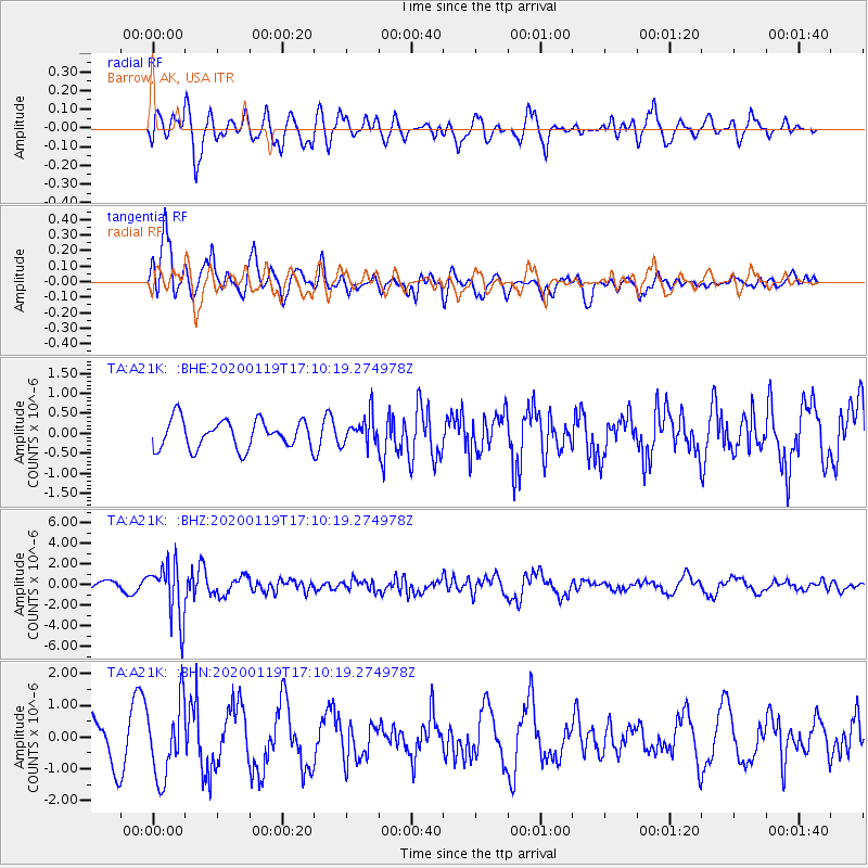
A21K Barrow, AK, USA - Earthquake Result Viewer
*The percent match for this event was below the threshold and hence no stack was calculated.
| Earthquake location: |
Minahassa Peninsula, Sulawesi |
| Earthquake latitude/longitude: |
-0.1/123.8 |
| Earthquake time(UTC): |
2020/01/19 (019) 16:58:19 GMT |
| Earthquake Depth: |
121 km |
| Earthquake Magnitude: |
6.1 Mww |
| Earthquake Catalog/Contributor: |
NEIC PDE/us |
|
| Network: |
TA USArray Transportable Network (new EarthScope stations) |
| Station: |
A21K Barrow, AK, USA |
| Lat/Lon: |
71.32 N/156.62 W |
| Elevation: |
577 m |
|
| Distance: |
86.8 deg |
| Az: |
18.505 deg |
| Baz: |
260.104 deg |
| Ray Param: |
$rayparam |
*The percent match for this event was below the threshold and hence was not used in the summary stack. |
|
| Radial Match: |
55.730137 % |
| Radial Bump: |
400 |
| Transverse Match: |
71.55552 % |
| Transverse Bump: |
400 |
| SOD ConfigId: |
20465011 |
| Insert Time: |
2020-02-02 17:04:48.438 +0000 |
| GWidth: |
2.5 |
| Max Bumps: |
400 |
| Tol: |
0.001 |
|
Signal To Noise
| Channel | StoN | STA | LTA |
| TA:A21K: :BHZ:20200119T17:10:19.274978Z | 7.199419 | 2.6698933E-6 | 3.7084843E-7 |
| TA:A21K: :BHN:20200119T17:10:19.274978Z | 2.1629806 | 1.1655401E-6 | 5.3885833E-7 |
| TA:A21K: :BHE:20200119T17:10:19.274978Z | 1.0482599 | 3.7087645E-7 | 3.5380202E-7 |
| Arrivals |
| Ps | |
| PpPs | |
| PsPs/PpSs | |


