You are here: Home > Network List > TA - USArray Transportable Network (new EarthScope stations) Stations List
> Station D23K Nanushuk River, AK USA > Earthquake Result Viewer
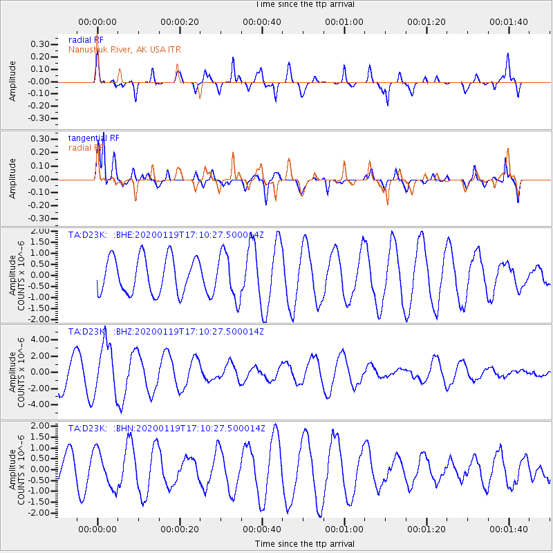
D23K Nanushuk River, AK USA - Earthquake Result Viewer
*The percent match for this event was below the threshold and hence no stack was calculated.
| Earthquake location: |
Minahassa Peninsula, Sulawesi |
| Earthquake latitude/longitude: |
-0.1/123.8 |
| Earthquake time(UTC): |
2020/01/19 (019) 16:58:19 GMT |
| Earthquake Depth: |
121 km |
| Earthquake Magnitude: |
6.1 Mww |
| Earthquake Catalog/Contributor: |
NEIC PDE/us |
|
| Network: |
TA USArray Transportable Network (new EarthScope stations) |
| Station: |
D23K Nanushuk River, AK USA |
| Lat/Lon: |
68.97 N/150.68 W |
| Elevation: |
406 m |
|
| Distance: |
88.5 deg |
| Az: |
21.104 deg |
| Baz: |
265.793 deg |
| Ray Param: |
$rayparam |
*The percent match for this event was below the threshold and hence was not used in the summary stack. |
|
| Radial Match: |
66.70046 % |
| Radial Bump: |
328 |
| Transverse Match: |
83.86736 % |
| Transverse Bump: |
400 |
| SOD ConfigId: |
20465011 |
| Insert Time: |
2020-02-02 17:05:04.950 +0000 |
| GWidth: |
2.5 |
| Max Bumps: |
400 |
| Tol: |
0.001 |
|
Signal To Noise
| Channel | StoN | STA | LTA |
| TA:D23K: :BHZ:20200119T17:10:27.500014Z | 1.7289855 | 3.1282655E-6 | 1.8093069E-6 |
| TA:D23K: :BHN:20200119T17:10:27.500014Z | 1.2195975 | 8.5396726E-7 | 7.0020417E-7 |
| TA:D23K: :BHE:20200119T17:10:27.500014Z | 1.2987007 | 1.050288E-6 | 8.087221E-7 |
| Arrivals |
| Ps | |
| PpPs | |
| PsPs/PpSs | |


