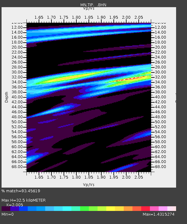
TIP Timpagrande, Italy - Earthquake Result Viewer
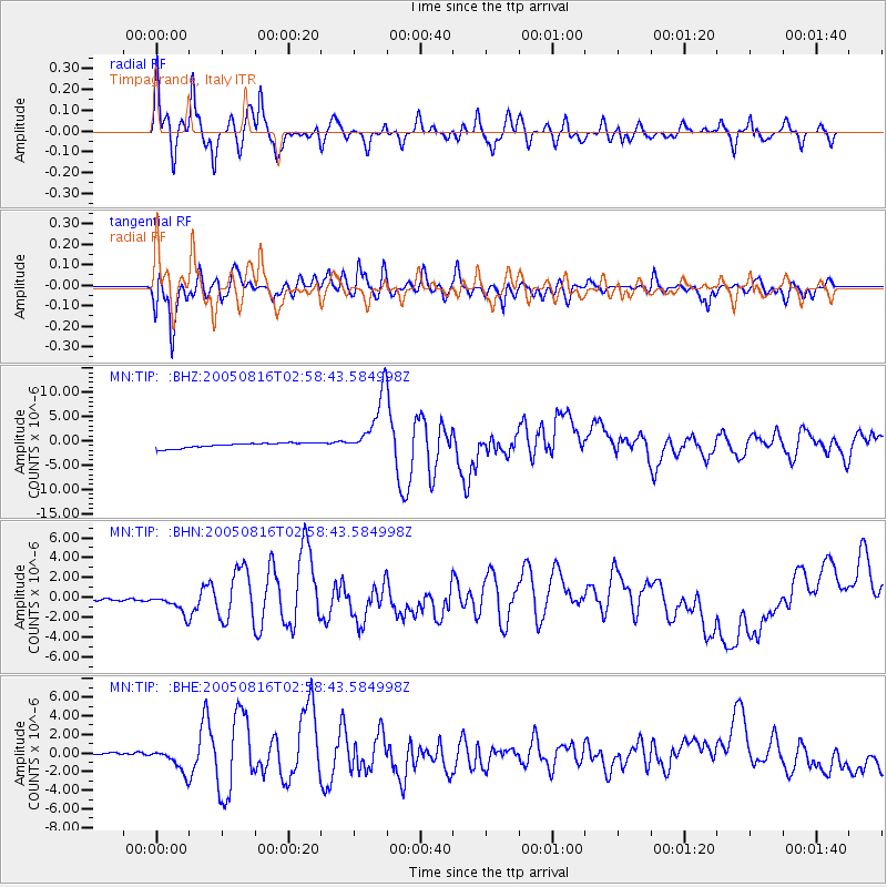
Earthquake location: Near East Coast Of Honshu, Japan
Earthquake latitude/longitude: 38.3/142.0
Earthquake time(UTC): 2005/08/16 (228) 02:46:28 GMT
Earthquake Depth: 36 km
Earthquake Magnitude: 6.5 MB, 6.8 MS, 7.2 MW, 7.1 MW
Earthquake Catalog/Contributor: WHDF/NEIC
Network: MN MEDNET Project
Station: TIP Timpagrande, Italy
Lat/Lon: 39.18 N/16.76 E
Elevation: 789 m
Distance: 88.0 deg
Az: 320.589 deg
Baz: 40.007 deg
Ray Param: 0.042859614
Estimated Moho Depth: 32.5 km
Estimated Crust Vp/Vs: 2.01
Assumed Crust Vp: 6.1 km/s
Estimated Crust Vs: 3.042 km/s
Estimated Crust Poisson's Ratio: 0.33
Radial Match: 93.45619 %
Radial Bump: 400
Transverse Match: 68.53244 %
Transverse Bump: 400
SOD ConfigId: 2475
Insert Time: 2010-03-08 17:22:49.975 +0000
GWidth: 2.5
Max Bumps: 400
Tol: 0.001

Signal To Noise

ChannelStoNSTALTA
MN:TIP: :BHN:20050816T02:58:43.584998Z2.08038781.4029837E-66.743856E-7
MN:TIP: :BHE:20050816T02:58:43.584998Z2.42214971.11347E-64.5970322E-7
MN:TIP: :BHZ:20050816T02:58:43.584998Z12.332416.396005E-65.1863384E-7
Arrivals
Ps5.4 SECOND
PpPs16 SECOND
PsPs/PpSs21 SECOND