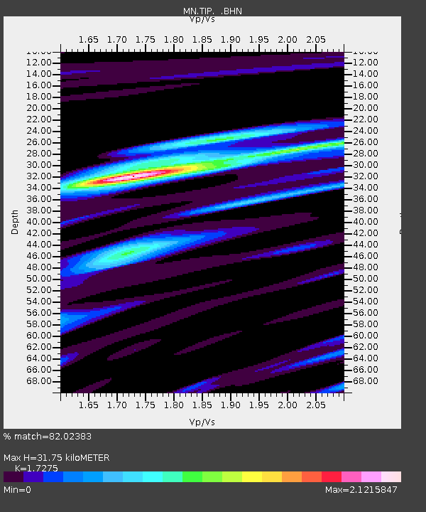
TIP Timpagrande, Italy - Earthquake Result Viewer
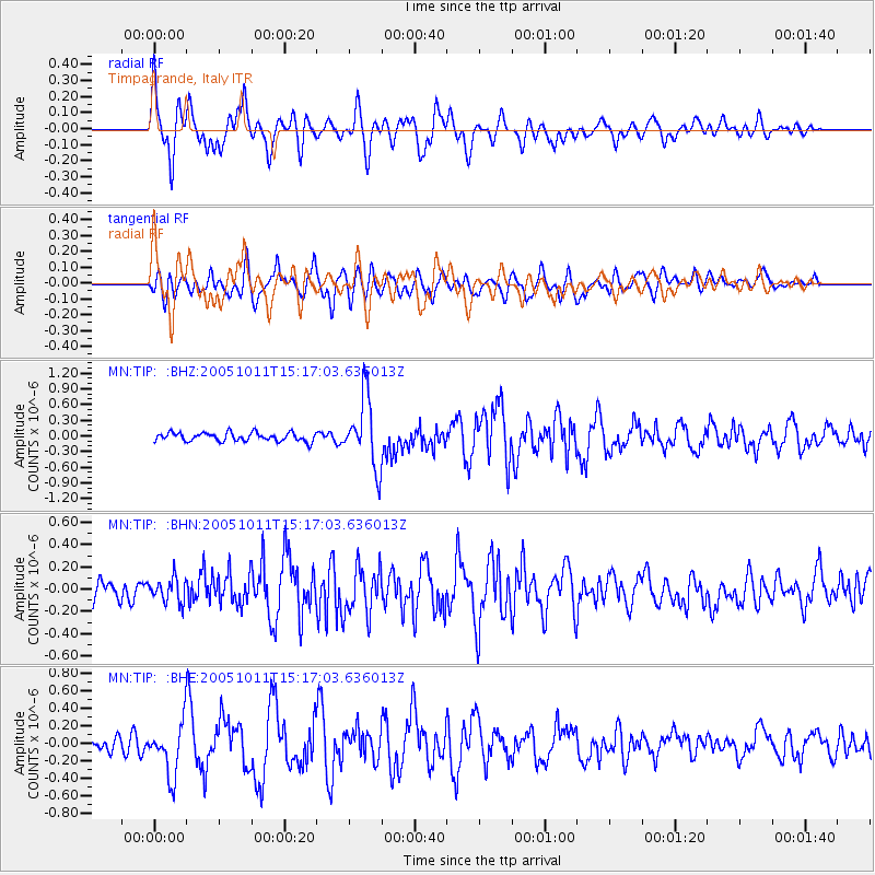
Earthquake location: Northern Sumatra, Indonesia
Earthquake latitude/longitude: 4.8/95.1
Earthquake time(UTC): 2005/10/11 (284) 15:05:39 GMT
Earthquake Depth: 30 km
Earthquake Magnitude: 6.0 MB, 5.3 MS, 5.9 MW, 5.9 MW
Earthquake Catalog/Contributor: WHDF/NEIC
Network: MN MEDNET Project
Station: TIP Timpagrande, Italy
Lat/Lon: 39.18 N/16.76 E
Elevation: 789 m
Distance: 77.9 deg
Az: 308.885 deg
Baz: 93.626 deg
Ray Param: 0.049945734
Estimated Moho Depth: 31.75 km
Estimated Crust Vp/Vs: 1.73
Assumed Crust Vp: 6.1 km/s
Estimated Crust Vs: 3.531 km/s
Estimated Crust Poisson's Ratio: 0.25
Radial Match: 82.02383 %
Radial Bump: 400
Transverse Match: 78.30897 %
Transverse Bump: 400
SOD ConfigId: 2475
Insert Time: 2010-03-08 17:22:56.322 +0000
GWidth: 2.5
Max Bumps: 400
Tol: 0.001

Signal To Noise

ChannelStoNSTALTA
MN:TIP: :BHN:20051011T15:17:03.636013Z1.69167161.0973819E-76.4869674E-8
MN:TIP: :BHE:20051011T15:17:03.636013Z3.56963592.9643576E-78.3043695E-8
MN:TIP: :BHZ:20051011T15:17:03.636013Z8.1737156.622535E-78.102234E-8
Arrivals
Ps3.9 SECOND
PpPs14 SECOND
PsPs/PpSs18 SECOND