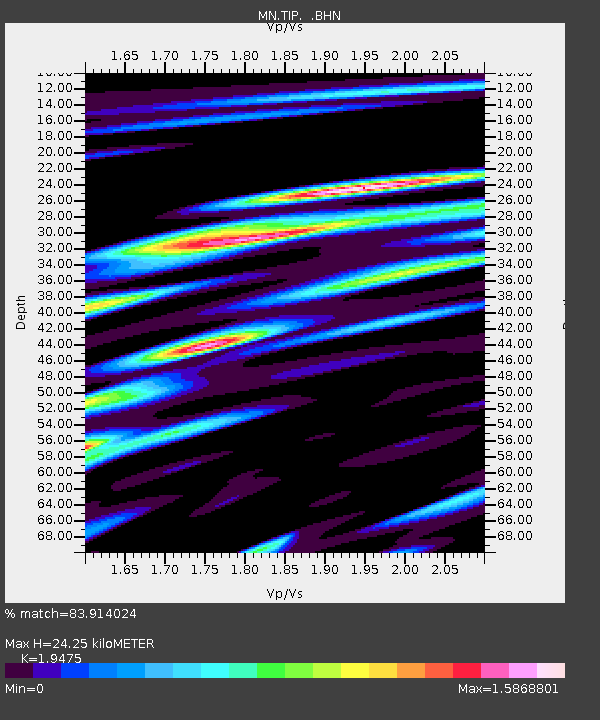
TIP Timpagrande, Italy - Earthquake Result Viewer

Earthquake location: Northern Sumatra, Indonesia
Earthquake latitude/longitude: 5.2/94.5
Earthquake time(UTC): 2005/07/30 (211) 15:13:20 GMT
Earthquake Depth: 38 km
Earthquake Magnitude: 5.8 MB, 5.2 MS, 5.8 MW, 5.8 MW
Earthquake Catalog/Contributor: WHDF/NEIC
Network: MN MEDNET Project
Station: TIP Timpagrande, Italy
Lat/Lon: 39.18 N/16.76 E
Elevation: 789 m
Distance: 77.2 deg
Az: 308.856 deg
Baz: 93.742 deg
Ray Param: 0.0504061
Estimated Moho Depth: 24.25 km
Estimated Crust Vp/Vs: 1.95
Assumed Crust Vp: 6.1 km/s
Estimated Crust Vs: 3.132 km/s
Estimated Crust Poisson's Ratio: 0.32
Radial Match: 83.914024 %
Radial Bump: 400
Transverse Match: 79.39756 %
Transverse Bump: 400
SOD ConfigId: 2500
Insert Time: 2010-03-08 17:22:57.800 +0000
GWidth: 2.5
Max Bumps: 400
Tol: 0.001

Signal To Noise

ChannelStoNSTALTA
MN:TIP: :BHN:20050730T15:24:39.286016Z0.784952346.7314055E-88.5755595E-8
MN:TIP: :BHE:20050730T15:24:39.286016Z4.49301532.3541816E-75.2396476E-8
MN:TIP: :BHZ:20050730T15:24:39.286016Z4.8478224.5498538E-79.3853565E-8
Arrivals
Ps3.9 SECOND
PpPs11 SECOND
PsPs/PpSs15 SECOND