You are here: Home > Network List > MN - MEDNET Project Stations List
> Station TIP Timpagrande, Italy > Earthquake Result Viewer
TIP Timpagrande, Italy - Earthquake Result Viewer
| Earthquake location: |
North Of Ascension Island |
| Earthquake latitude/longitude: |
-1.4/-13.3 |
| Earthquake time(UTC): |
2007/11/27 (331) 10:13:49 GMT |
| Earthquake Depth: |
10 km |
| Earthquake Magnitude: |
5.7 MB, 5.2 MS |
| Earthquake Catalog/Contributor: |
WHDF/NEIC |
|
| Network: |
MN MEDNET Project |
| Station: |
TIP Timpagrande, Italy |
| Lat/Lon: |
39.18 N/16.76 E |
| Elevation: |
789 m |
|
| Distance: |
48.9 deg |
| Az: |
31.113 deg |
| Baz: |
221.654 deg |
| Ray Param: |
0.069075346 |
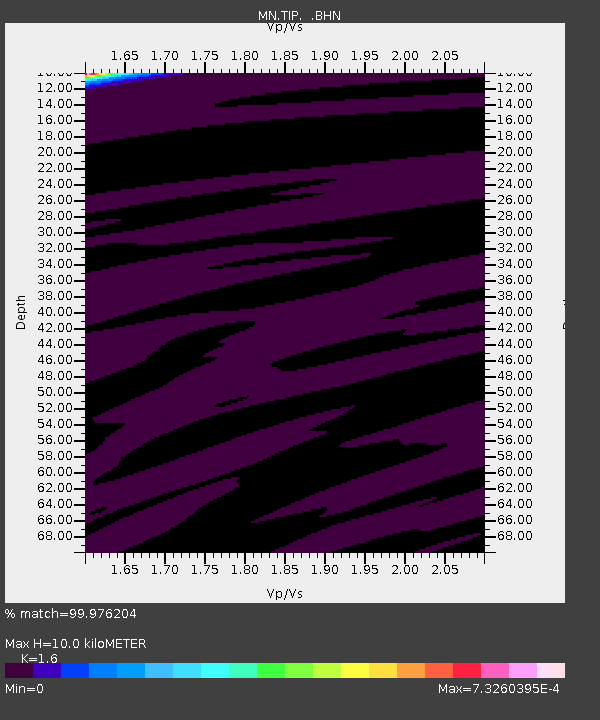
| Estimated Moho Depth: |
10.0 km |
| Estimated Crust Vp/Vs: |
1.60 |
| Assumed Crust Vp: |
6.1 km/s |
| Estimated Crust Vs: |
3.812 km/s |
| Estimated Crust Poisson's Ratio: |
0.18 |
|
| Radial Match: |
99.976204 % |
| Radial Bump: |
5 |
| Transverse Match: |
99.71548 % |
| Transverse Bump: |
24 |
| SOD ConfigId: |
2564 |
| Insert Time: |
2010-03-08 17:23:02.569 +0000 |
| GWidth: |
2.5 |
| Max Bumps: |
400 |
| Tol: |
0.001 |
|
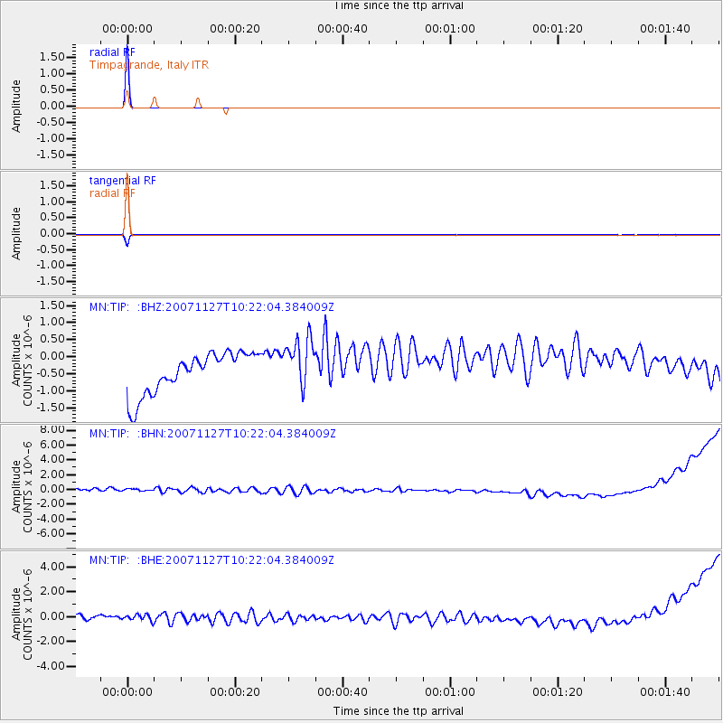
Signal To Noise
| Channel | StoN | STA | LTA |
| MN:TIP: :BHN:20071127T10:22:04.384009Z | 0.85861254 | 6.039145E-7 | 7.033609E-7 |
| MN:TIP: :BHE:20071127T10:22:04.384009Z | 0.9431268 | 4.1910238E-7 | 4.4437542E-7 |
| MN:TIP: :BHZ:20071127T10:22:04.384009Z | 1.2849294 | 7.629426E-7 | 5.9376225E-7 |
| Arrivals |
| Ps | 1.0 SECOND |
| PpPs | 4.0 SECOND |
| PsPs/PpSs | 5.1 SECOND |


