You are here: Home > Network List > MN - MEDNET Project Stations List
> Station TIP Timpagrande, Italy > Earthquake Result Viewer
TIP Timpagrande, Italy - Earthquake Result Viewer
| Earthquake location: |
Peru-Ecuador Border Region |
| Earthquake latitude/longitude: |
-2.3/-77.8 |
| Earthquake time(UTC): |
2007/11/16 (320) 03:13:00 GMT |
| Earthquake Depth: |
123 km |
| Earthquake Magnitude: |
6.3 MB, 6.8 MW, 6.7 MW |
| Earthquake Catalog/Contributor: |
WHDF/NEIC |
|
| Network: |
MN MEDNET Project |
| Station: |
TIP Timpagrande, Italy |
| Lat/Lon: |
39.18 N/16.76 E |
| Elevation: |
789 m |
|
| Distance: |
95.0 deg |
| Az: |
51.053 deg |
| Baz: |
271.106 deg |
| Ray Param: |
0.0408035 |
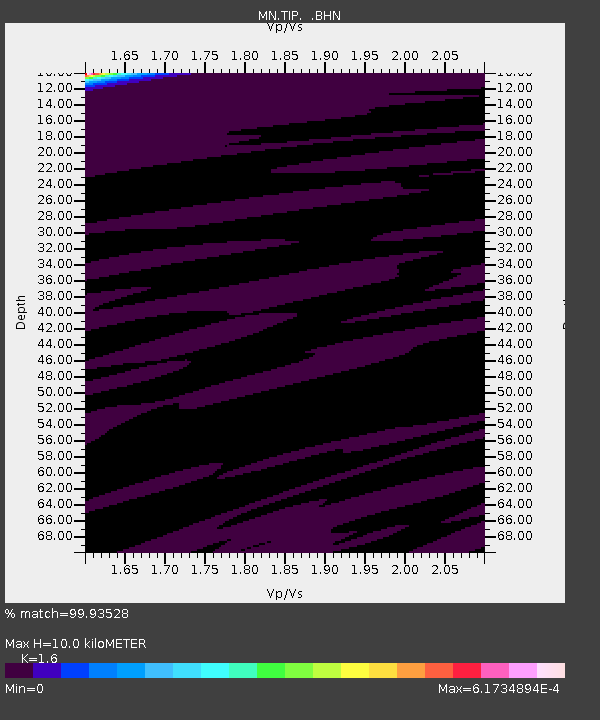
| Estimated Moho Depth: |
10.0 km |
| Estimated Crust Vp/Vs: |
1.60 |
| Assumed Crust Vp: |
6.1 km/s |
| Estimated Crust Vs: |
3.812 km/s |
| Estimated Crust Poisson's Ratio: |
0.18 |
|
| Radial Match: |
99.93528 % |
| Radial Bump: |
6 |
| Transverse Match: |
99.94576 % |
| Transverse Bump: |
8 |
| SOD ConfigId: |
2564 |
| Insert Time: |
2010-03-08 17:23:03.741 +0000 |
| GWidth: |
2.5 |
| Max Bumps: |
400 |
| Tol: |
0.001 |
|

Signal To Noise
| Channel | StoN | STA | LTA |
| MN:TIP: :BHN:20071116T03:25:37.536016Z | 0.866009 | 5.567214E-7 | 6.4285865E-7 |
| MN:TIP: :BHE:20071116T03:25:37.536016Z | 1.2892276 | 4.930545E-7 | 3.8244175E-7 |
| MN:TIP: :BHZ:20071116T03:25:37.536016Z | 1.7644266 | 9.676224E-7 | 5.484062E-7 |
| Arrivals |
| Ps | 1.0 SECOND |
| PpPs | 4.2 SECOND |
| PsPs/PpSs | 5.2 SECOND |


