You are here: Home > Network List > MN - MEDNET Project Stations List
> Station TIP Timpagrande, Italy > Earthquake Result Viewer
TIP Timpagrande, Italy - Earthquake Result Viewer
| Earthquake location: |
Near West Coast Of Colombia |
| Earthquake latitude/longitude: |
3.0/-78.0 |
| Earthquake time(UTC): |
2007/09/10 (253) 01:49:14 GMT |
| Earthquake Depth: |
31 km |
| Earthquake Magnitude: |
6.1 MB, 6.7 MS, 6.8 MW |
| Earthquake Catalog/Contributor: |
WHDF/NEIC |
|
| Network: |
MN MEDNET Project |
| Station: |
TIP Timpagrande, Italy |
| Lat/Lon: |
39.18 N/16.76 E |
| Elevation: |
789 m |
|
| Distance: |
91.8 deg |
| Az: |
50.804 deg |
| Baz: |
275.277 deg |
| Ray Param: |
0.04154708 |
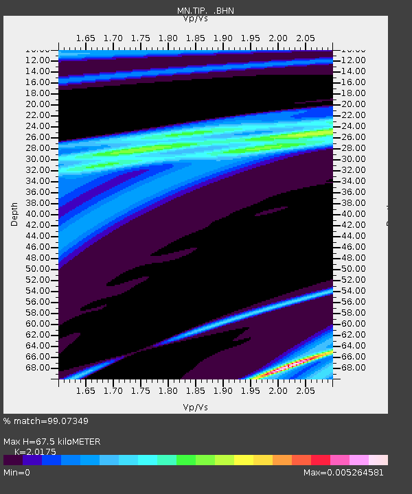
| Estimated Moho Depth: |
67.5 km |
| Estimated Crust Vp/Vs: |
2.02 |
| Assumed Crust Vp: |
6.1 km/s |
| Estimated Crust Vs: |
3.024 km/s |
| Estimated Crust Poisson's Ratio: |
0.34 |
|
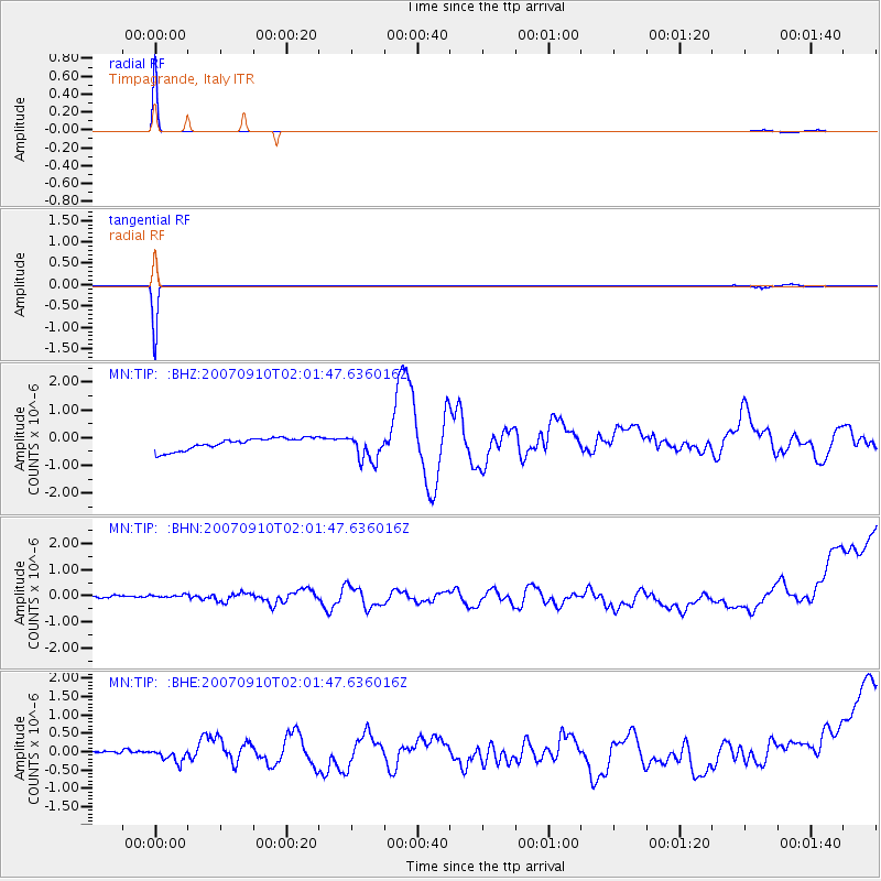
| Radial Match: |
99.07349 % |
| Radial Bump: |
42 |
| Transverse Match: |
99.57035 % |
| Transverse Bump: |
27 |
| SOD ConfigId: |
2564 |
| Insert Time: |
2010-03-08 17:23:07.204 +0000 |
| GWidth: |
2.5 |
| Max Bumps: |
400 |
| Tol: |
0.001 |
|
Signal To Noise
| Channel | StoN | STA | LTA |
| MN:TIP: :BHN:20070910T02:01:47.636016Z | 0.97820854 | 2.5200345E-7 | 2.576173E-7 |
| MN:TIP: :BHE:20070910T02:01:47.636016Z | 0.83191556 | 1.3657404E-7 | 1.6416816E-7 |
| MN:TIP: :BHZ:20070910T02:01:47.636016Z | 2.239978 | 4.8191697E-7 | 2.1514361E-7 |
| Arrivals |
| Ps | 11 SECOND |
| PpPs | 33 SECOND |
| PsPs/PpSs | 44 SECOND |


