You are here: Home > Network List > MN - MEDNET Project Stations List
> Station TIP Timpagrande, Italy > Earthquake Result Viewer
TIP Timpagrande, Italy - Earthquake Result Viewer
| Earthquake location: |
Central Mid-Atlantic Ridge |
| Earthquake latitude/longitude: |
8.0/-39.2 |
| Earthquake time(UTC): |
2007/08/20 (232) 22:42:29 GMT |
| Earthquake Depth: |
10 km |
| Earthquake Magnitude: |
6.3 MB, 6.4 MS, 6.5 MW |
| Earthquake Catalog/Contributor: |
WHDF/NEIC |
|
| Network: |
MN MEDNET Project |
| Station: |
TIP Timpagrande, Italy |
| Lat/Lon: |
39.18 N/16.76 E |
| Elevation: |
789 m |
|
| Distance: |
58.8 deg |
| Az: |
48.871 deg |
| Baz: |
253.68 deg |
| Ray Param: |
0.0625963 |
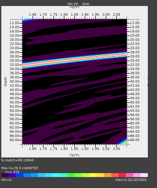
| Estimated Moho Depth: |
29.5 km |
| Estimated Crust Vp/Vs: |
1.83 |
| Assumed Crust Vp: |
6.1 km/s |
| Estimated Crust Vs: |
3.342 km/s |
| Estimated Crust Poisson's Ratio: |
0.29 |
|
| Radial Match: |
99.18948 % |
| Radial Bump: |
26 |
| Transverse Match: |
98.73104 % |
| Transverse Bump: |
26 |
| SOD ConfigId: |
2564 |
| Insert Time: |
2010-03-08 17:23:08.329 +0000 |
| GWidth: |
2.5 |
| Max Bumps: |
400 |
| Tol: |
0.001 |
|
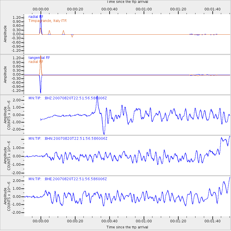
Signal To Noise
| Channel | StoN | STA | LTA |
| MN:TIP: :BHN:20070820T22:51:56.586006Z | 1.3080645 | 2.96632E-7 | 2.2677172E-7 |
| MN:TIP: :BHE:20070820T22:51:56.586006Z | 3.5025961 | 4.803199E-7 | 1.3713255E-7 |
| MN:TIP: :BHZ:20070820T22:51:56.586006Z | 6.378028 | 1.184672E-6 | 1.8574268E-7 |
| Arrivals |
| Ps | 4.2 SECOND |
| PpPs | 13 SECOND |
| PsPs/PpSs | 17 SECOND |


