You are here: Home > Network List > MN - MEDNET Project Stations List
> Station TIP Timpagrande, Italy > Earthquake Result Viewer
TIP Timpagrande, Italy - Earthquake Result Viewer
| Earthquake location: |
Central Mid-Atlantic Ridge |
| Earthquake latitude/longitude: |
-0.3/-18.2 |
| Earthquake time(UTC): |
2007/08/20 (232) 12:37:06 GMT |
| Earthquake Depth: |
10 km |
| Earthquake Magnitude: |
5.7 MB, 5.1 MS, 5.7 MW |
| Earthquake Catalog/Contributor: |
WHDF/NEIC |
|
| Network: |
MN MEDNET Project |
| Station: |
TIP Timpagrande, Italy |
| Lat/Lon: |
39.18 N/16.76 E |
| Elevation: |
789 m |
|
| Distance: |
50.6 deg |
| Az: |
35.153 deg |
| Baz: |
227.797 deg |
| Ray Param: |
0.06793143 |
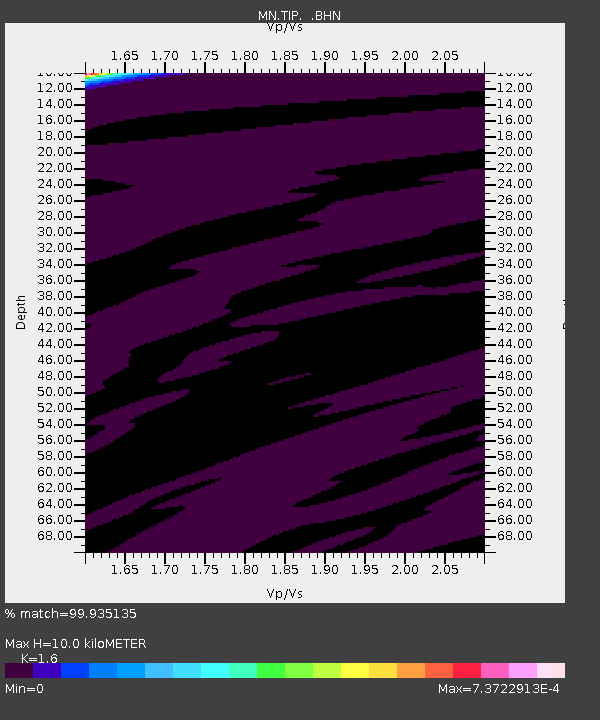
| Estimated Moho Depth: |
10.0 km |
| Estimated Crust Vp/Vs: |
1.60 |
| Assumed Crust Vp: |
6.1 km/s |
| Estimated Crust Vs: |
3.812 km/s |
| Estimated Crust Poisson's Ratio: |
0.18 |
|
| Radial Match: |
99.935135 % |
| Radial Bump: |
13 |
| Transverse Match: |
99.69259 % |
| Transverse Bump: |
22 |
| SOD ConfigId: |
2564 |
| Insert Time: |
2010-03-08 17:23:10.011 +0000 |
| GWidth: |
2.5 |
| Max Bumps: |
400 |
| Tol: |
0.001 |
|
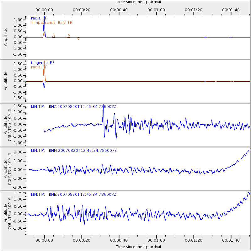
Signal To Noise
| Channel | StoN | STA | LTA |
| MN:TIP: :BHN:20070820T12:45:34.786007Z | 1.03265 | 2.131958E-7 | 2.0645506E-7 |
| MN:TIP: :BHE:20070820T12:45:34.786007Z | 1.8592561 | 2.4550917E-7 | 1.3204699E-7 |
| MN:TIP: :BHZ:20070820T12:45:34.786007Z | 3.3342512 | 5.815321E-7 | 1.7441161E-7 |
| Arrivals |
| Ps | 1.0 SECOND |
| PpPs | 4.0 SECOND |
| PsPs/PpSs | 5.1 SECOND |


