You are here: Home > Network List > MN - MEDNET Project Stations List
> Station TIP Timpagrande, Italy > Earthquake Result Viewer
TIP Timpagrande, Italy - Earthquake Result Viewer
| Earthquake location: |
Northern Mid-Atlantic Ridge |
| Earthquake latitude/longitude: |
25.9/-45.0 |
| Earthquake time(UTC): |
2007/08/09 (221) 17:25:05 GMT |
| Earthquake Depth: |
10 km |
| Earthquake Magnitude: |
5.6 MW, 5.1 MS, 5.2 MB |
| Earthquake Catalog/Contributor: |
WHDF/NEIC |
|
| Network: |
MN MEDNET Project |
| Station: |
TIP Timpagrande, Italy |
| Lat/Lon: |
39.18 N/16.76 E |
| Elevation: |
789 m |
|
| Distance: |
52.8 deg |
| Az: |
59.288 deg |
| Baz: |
275.025 deg |
| Ray Param: |
0.066533744 |
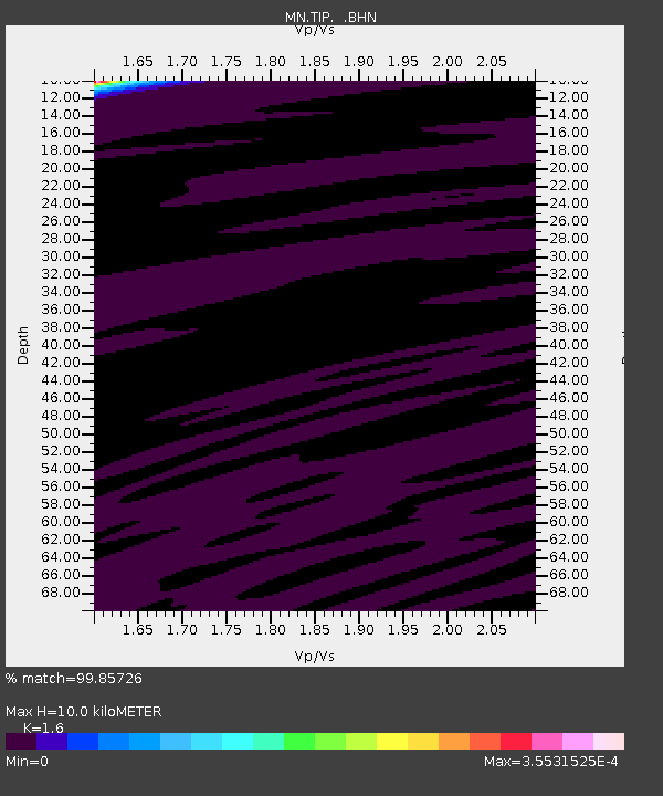
| Estimated Moho Depth: |
10.0 km |
| Estimated Crust Vp/Vs: |
1.60 |
| Assumed Crust Vp: |
6.1 km/s |
| Estimated Crust Vs: |
3.812 km/s |
| Estimated Crust Poisson's Ratio: |
0.18 |
|
| Radial Match: |
99.85726 % |
| Radial Bump: |
17 |
| Transverse Match: |
99.95006 % |
| Transverse Bump: |
7 |
| SOD ConfigId: |
2564 |
| Insert Time: |
2010-03-08 17:23:11.157 +0000 |
| GWidth: |
2.5 |
| Max Bumps: |
400 |
| Tol: |
0.001 |
|
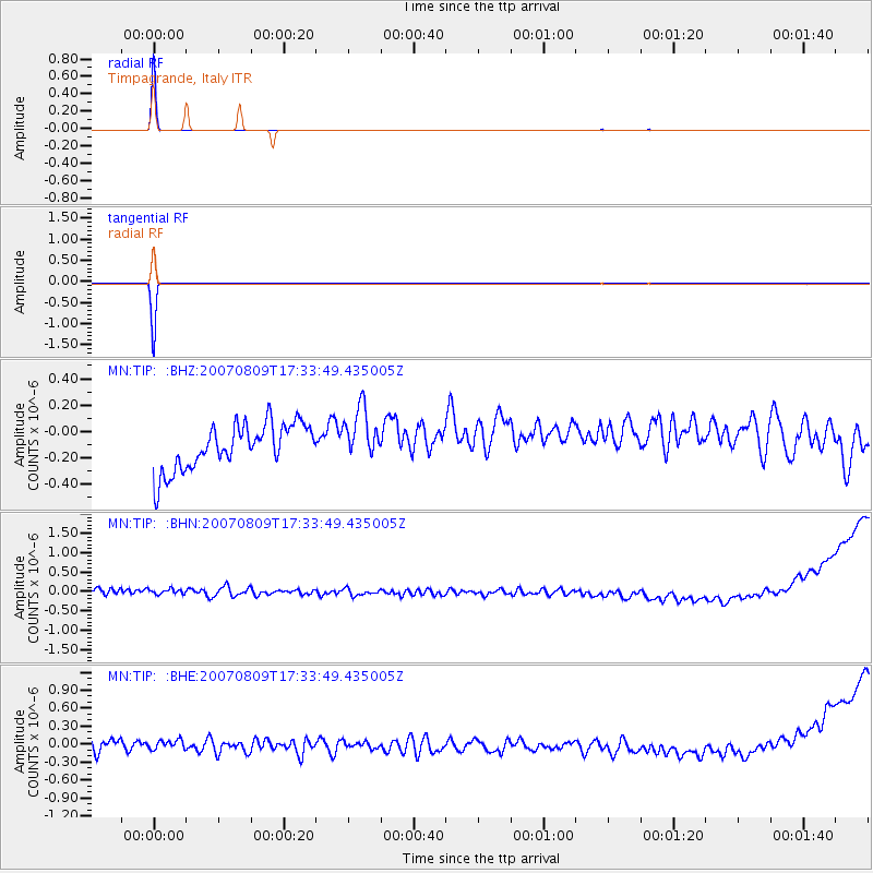
Signal To Noise
| Channel | StoN | STA | LTA |
| MN:TIP: :BHN:20070809T17:33:49.435005Z | 0.85429925 | 1.5863753E-7 | 1.8569317E-7 |
| MN:TIP: :BHE:20070809T17:33:49.435005Z | 0.98731965 | 1.2205537E-7 | 1.2362295E-7 |
| MN:TIP: :BHZ:20070809T17:33:49.435005Z | 1.1714065 | 2.0142772E-7 | 1.7195374E-7 |
| Arrivals |
| Ps | 1.0 SECOND |
| PpPs | 4.0 SECOND |
| PsPs/PpSs | 5.1 SECOND |


