You are here: Home > Network List > C1 - Red Sismologica Nacional Stations List
> Station MT10 Hacienda Santa Martina > Earthquake Result Viewer
MT10 Hacienda Santa Martina - Earthquake Result Viewer
| Earthquake location: |
South Sandwich Islands Region |
| Earthquake latitude/longitude: |
-59.2/-26.3 |
| Earthquake time(UTC): |
2020/01/20 (020) 06:51:37 GMT |
| Earthquake Depth: |
91 km |
| Earthquake Magnitude: |
6.1 Mww |
| Earthquake Catalog/Contributor: |
NEIC PDE/us |
|
| Network: |
C1 Red Sismologica Nacional |
| Station: |
MT10 Hacienda Santa Martina |
| Lat/Lon: |
33.27 S/70.54 W |
| Elevation: |
1410 m |
|
| Distance: |
39.0 deg |
| Az: |
291.803 deg |
| Baz: |
145.268 deg |
| Ray Param: |
0.07492918 |
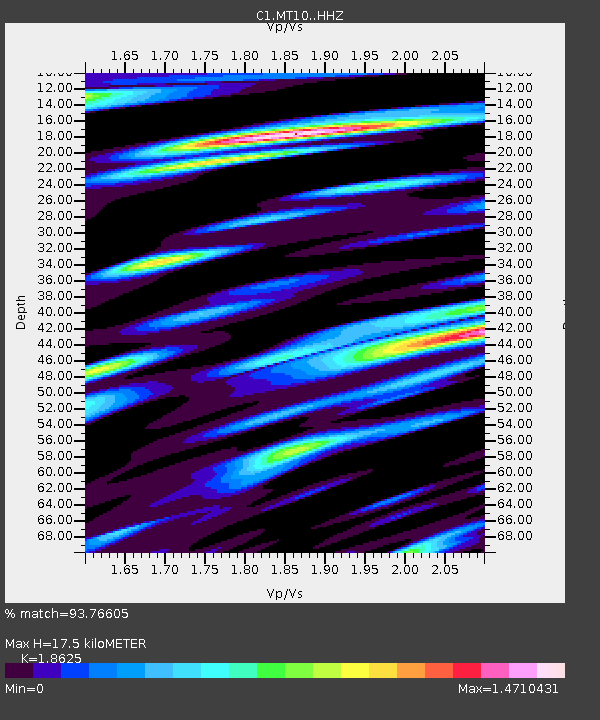
| Estimated Moho Depth: |
17.5 km |
| Estimated Crust Vp/Vs: |
1.86 |
| Assumed Crust Vp: |
6.481 km/s |
| Estimated Crust Vs: |
3.48 km/s |
| Estimated Crust Poisson's Ratio: |
0.30 |
|
| Radial Match: |
93.76605 % |
| Radial Bump: |
400 |
| Transverse Match: |
87.44738 % |
| Transverse Bump: |
400 |
| SOD ConfigId: |
20465011 |
| Insert Time: |
2020-02-03 06:53:41.272 +0000 |
| GWidth: |
2.5 |
| Max Bumps: |
400 |
| Tol: |
0.001 |
|

Signal To Noise
| Channel | StoN | STA | LTA |
| C1:MT10: :HHZ:20200120T06:58:25.038003Z | 31.590052 | 1.2075658E-5 | 3.822614E-7 |
| C1:MT10: :HHN:20200120T06:58:25.038003Z | 22.168537 | 6.518376E-6 | 2.9403725E-7 |
| C1:MT10: :HHE:20200120T06:58:25.038003Z | 8.245297 | 3.9403303E-6 | 4.778882E-7 |
| Arrivals |
| Ps | 2.5 SECOND |
| PpPs | 7.2 SECOND |
| PsPs/PpSs | 9.7 SECOND |


