You are here: Home > Network List > MN - MEDNET Project Stations List
> Station TIP Timpagrande, Italy > Earthquake Result Viewer
TIP Timpagrande, Italy - Earthquake Result Viewer
| Earthquake location: |
Western Brazil |
| Earthquake latitude/longitude: |
-8.1/-71.3 |
| Earthquake time(UTC): |
2007/07/21 (202) 13:27:04 GMT |
| Earthquake Depth: |
645 km |
| Earthquake Magnitude: |
6.2 MB, 6.1 MW, 6.0 MW |
| Earthquake Catalog/Contributor: |
WHDF/NEIC |
|
| Network: |
MN MEDNET Project |
| Station: |
TIP Timpagrande, Italy |
| Lat/Lon: |
39.18 N/16.76 E |
| Elevation: |
789 m |
|
| Distance: |
93.6 deg |
| Az: |
51.103 deg |
| Baz: |
262.478 deg |
| Ray Param: |
0.040621344 |
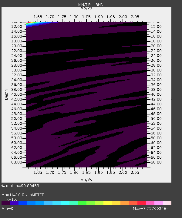
| Estimated Moho Depth: |
10.0 km |
| Estimated Crust Vp/Vs: |
1.60 |
| Assumed Crust Vp: |
6.1 km/s |
| Estimated Crust Vs: |
3.812 km/s |
| Estimated Crust Poisson's Ratio: |
0.18 |
|
| Radial Match: |
99.89458 % |
| Radial Bump: |
16 |
| Transverse Match: |
99.89634 % |
| Transverse Bump: |
12 |
| SOD ConfigId: |
2564 |
| Insert Time: |
2010-03-08 17:23:14.673 +0000 |
| GWidth: |
2.5 |
| Max Bumps: |
400 |
| Tol: |
0.001 |
|
Signal To Noise
| Channel | StoN | STA | LTA |
| MN:TIP: :BHN:20070721T13:38:41.985012Z | 1.6210281 | 2.0972007E-7 | 1.2937474E-7 |
| MN:TIP: :BHE:20070721T13:38:41.985012Z | 4.8303504 | 3.1243954E-7 | 6.468259E-8 |
| MN:TIP: :BHZ:20070721T13:38:41.985012Z | 6.4703856 | 6.989797E-7 | 1.08027514E-7 |
| Arrivals |
| Ps | 1.0 SECOND |
| PpPs | 4.2 SECOND |
| PsPs/PpSs | 5.2 SECOND |


