You are here: Home > Network List > MN - MEDNET Project Stations List
> Station TIP Timpagrande, Italy > Earthquake Result Viewer
TIP Timpagrande, Italy - Earthquake Result Viewer
| Earthquake location: |
Northern Colombia |
| Earthquake latitude/longitude: |
7.2/-72.1 |
| Earthquake time(UTC): |
2007/07/16 (197) 22:58:23 GMT |
| Earthquake Depth: |
30 km |
| Earthquake Magnitude: |
5.5 MB, 4.5 MS, 5.1 MW, 5.6 ML |
| Earthquake Catalog/Contributor: |
WHDF/NEIC |
|
| Network: |
MN MEDNET Project |
| Station: |
TIP Timpagrande, Italy |
| Lat/Lon: |
39.18 N/16.76 E |
| Elevation: |
789 m |
|
| Distance: |
84.7 deg |
| Az: |
51.306 deg |
| Baz: |
274.861 deg |
| Ray Param: |
0.045290783 |
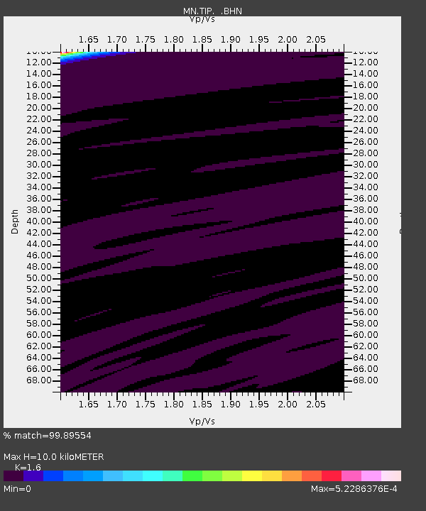
| Estimated Moho Depth: |
10.0 km |
| Estimated Crust Vp/Vs: |
1.60 |
| Assumed Crust Vp: |
6.1 km/s |
| Estimated Crust Vs: |
3.812 km/s |
| Estimated Crust Poisson's Ratio: |
0.18 |
|
| Radial Match: |
99.89554 % |
| Radial Bump: |
11 |
| Transverse Match: |
99.95316 % |
| Transverse Bump: |
8 |
| SOD ConfigId: |
2564 |
| Insert Time: |
2010-03-08 17:23:15.868 +0000 |
| GWidth: |
2.5 |
| Max Bumps: |
400 |
| Tol: |
0.001 |
|
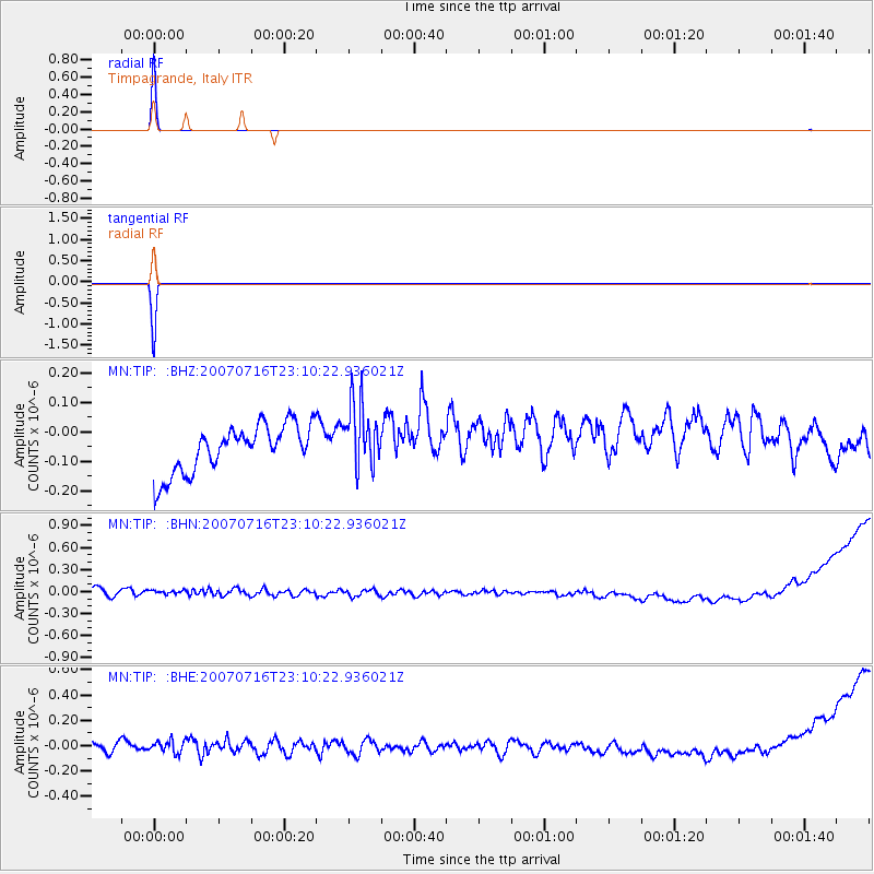
Signal To Noise
| Channel | StoN | STA | LTA |
| MN:TIP: :BHN:20070716T23:10:22.936021Z | 0.92624766 | 8.574976E-8 | 9.257757E-8 |
| MN:TIP: :BHE:20070716T23:10:22.936021Z | 1.1240319 | 6.531533E-8 | 5.8108068E-8 |
| MN:TIP: :BHZ:20070716T23:10:22.936021Z | 1.4325926 | 1.1451307E-7 | 7.9934146E-8 |
| Arrivals |
| Ps | 1.0 SECOND |
| PpPs | 4.2 SECOND |
| PsPs/PpSs | 5.2 SECOND |


