You are here: Home > Network List > MN - MEDNET Project Stations List
> Station TIP Timpagrande, Italy > Earthquake Result Viewer
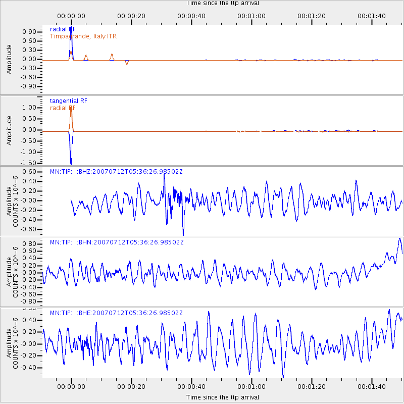
TIP Timpagrande, Italy - Earthquake Result Viewer

| Earthquake location: |
Peru-Brazil Border Region |
| Earthquake latitude/longitude: |
-7.9/-74.4 |
| Earthquake time(UTC): |
2007/07/12 (193) 05:23:49 GMT |
| Earthquake Depth: |
152 km |
| Earthquake Magnitude: |
5.9 MB, 6.1 MW, 6.0 MW |
| Earthquake Catalog/Contributor: |
WHDF/NEIC |
|
| Network: |
MN MEDNET Project |
| Station: |
TIP Timpagrande, Italy |
| Lat/Lon: |
39.18 N/16.76 E |
| Elevation: |
789 m |
|
| Distance: |
95.8 deg |
| Az: |
51.364 deg |
| Baz: |
264.567 deg |
| Ray Param: |
0.040563133 |
| Estimated Moho Depth: |
67.5 km |
| Estimated Crust Vp/Vs: |
1.97 |
| Assumed Crust Vp: |
6.1 km/s |
| Estimated Crust Vs: |
3.096 km/s |
| Estimated Crust Poisson's Ratio: |
0.33 |
|
| Radial Match: |
97.81858 % |
| Radial Bump: |
55 |
| Transverse Match: |
98.289276 % |
| Transverse Bump: |
48 |
| SOD ConfigId: |
2564 |
| Insert Time: |
2010-03-08 17:23:16.999 +0000 |
| GWidth: |
2.5 |
| Max Bumps: |
400 |
| Tol: |
0.001 |
|
Signal To Noise
| Channel | StoN | STA | LTA |
| MN:TIP: :BHN:20070712T05:36:26.98502Z | 1.5784382 | 2.4249627E-7 | 1.5363051E-7 |
| MN:TIP: :BHE:20070712T05:36:26.98502Z | 0.7159143 | 1.18584744E-7 | 1.6564097E-7 |
| MN:TIP: :BHZ:20070712T05:36:26.98502Z | 1.5691496 | 2.424424E-7 | 1.5450561E-7 |
| Arrivals |
| Ps | 11 SECOND |
| PpPs | 32 SECOND |
| PsPs/PpSs | 43 SECOND |


