You are here: Home > Network List > MN - MEDNET Project Stations List
> Station TIP Timpagrande, Italy > Earthquake Result Viewer
TIP Timpagrande, Italy - Earthquake Result Viewer
| Earthquake location: |
Hokkaido, Japan Region |
| Earthquake latitude/longitude: |
43.7/144.7 |
| Earthquake time(UTC): |
2007/07/01 (182) 04:12:07 GMT |
| Earthquake Depth: |
130 km |
| Earthquake Magnitude: |
5.5 MB, 5.8 MW, 5.8 MW |
| Earthquake Catalog/Contributor: |
WHDF/NEIC |
|
| Network: |
MN MEDNET Project |
| Station: |
TIP Timpagrande, Italy |
| Lat/Lon: |
39.18 N/16.76 E |
| Elevation: |
789 m |
|
| Distance: |
85.1 deg |
| Az: |
322.052 deg |
| Baz: |
35.043 deg |
| Ray Param: |
0.04473102 |
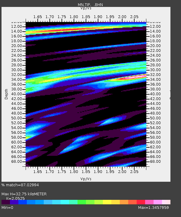
| Estimated Moho Depth: |
32.75 km |
| Estimated Crust Vp/Vs: |
2.05 |
| Assumed Crust Vp: |
6.1 km/s |
| Estimated Crust Vs: |
2.972 km/s |
| Estimated Crust Poisson's Ratio: |
0.34 |
|
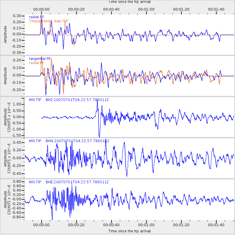
| Radial Match: |
87.02994 % |
| Radial Bump: |
400 |
| Transverse Match: |
87.5794 % |
| Transverse Bump: |
400 |
| SOD ConfigId: |
2564 |
| Insert Time: |
2010-03-08 17:23:18.194 +0000 |
| GWidth: |
2.5 |
| Max Bumps: |
400 |
| Tol: |
0.001 |
|
Signal To Noise
| Channel | StoN | STA | LTA |
| MN:TIP: :BHN:20070701T04:23:57.786011Z | 2.5614817 | 1.0145733E-7 | 3.9608846E-8 |
| MN:TIP: :BHE:20070701T04:23:57.786011Z | 2.2465382 | 1.4271649E-7 | 6.3527295E-8 |
| MN:TIP: :BHZ:20070701T04:23:57.786011Z | 14.93427 | 7.1341304E-7 | 4.77702E-8 |
| Arrivals |
| Ps | 5.8 SECOND |
| PpPs | 16 SECOND |
| PsPs/PpSs | 22 SECOND |


